Slika:Volga.A2002137.0745.250m.jpg

Izvorna datoteka (4.600 × 6.000 točk, velikost datoteke: 3,91 MB, MIME-vrsta: image/jpeg)
Spodaj prikazane informacije so s tamkajšnje opisne strani.
http://visibleearth.nasa.gov/view_rec.php?id=3823
Credit: Jacques Descloitres, MODIS Land Rapid Response Team, NASA/GSFC
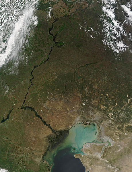
This MODIS image from May 17, 2002, shows the Volga River running north-south and emptying into the Caspian Sea. At lower left, extensive cultivation of the land can be seen in the regular patterns of fields. The light-colored waters of the Caspian Sea may be due to high sediment in the rivers that flow into it, as well as pollution and aquatic plant growth.
Metadata
- Sensor: Terra/MODIS
- Datastart: 2002-05-17
- Dataend: 2002-05-17
- Visible Earth v1 ID 19787
- Visualization Date: 2002-05-24
1. All Sensors 2. » MODIS
| Ta datoteka je v javni domeni, ker jo je izdelala izključno NASA. Avtorskopravna politika NASE pravi, da »Gradivo NASE ni zaščiteno z avtorskimi pravicami, razen če je rečeno drugače.« (glej Template:PD-USGov, stran z avtorskopravno politiko NASE ali Politiko uporabe slik JPL.) | ||
 |
Opozorila:
|
Zgodovina datoteke
Kliknite datum in čas za ogled datoteke, ki je bila takrat naložena.
| Datum in čas | Sličica | Velikost | Uporabnik | Komentar | |
|---|---|---|---|---|---|
| trenutno | 23:38, 25. avgust 2005 | | 4.600 × 6.000 (3,91 MB) | Nanosmile | http://visibleearth.nasa.gov/view_rec.php?id=3823 Credit: Jacques Descloitres, MODIS Land Rapid Response Team, NASA/GSFC This MODIS image from May 17, 2002, shows the Volga River running north-south and emptying into the Caspian Sea. At lower left, exte |
Uporaba datoteke
Datoteka je del naslednje 1 strani slovenske Wikipedije (strani drugih projektov niso navedene):
Globalna uporaba datoteke
To datoteko uporabljajo tudi naslednji vikiji:
- Uporaba na ar.wikipedia.org
- Uporaba na as.wikipedia.org
- Uporaba na av.wikipedia.org
- Uporaba na bg.wikipedia.org
- Uporaba na bh.wikipedia.org
- Uporaba na bn.wikipedia.org
- Uporaba na ca.wikipedia.org
- Uporaba na cv.wikipedia.org
- Uporaba na cy.wikipedia.org
- Uporaba na el.wikipedia.org
- Uporaba na en.wikipedia.org
- Uporaba na es.wikipedia.org
- Uporaba na gl.wikipedia.org
- Uporaba na it.wikipedia.org
- Uporaba na lad.wikipedia.org
- Uporaba na no.wikipedia.org
- Uporaba na pa.wikipedia.org
- Uporaba na pnb.wikipedia.org
- Uporaba na ro.wikipedia.org
- Uporaba na tl.wikipedia.org
- Uporaba na tr.wikipedia.org
- Uporaba na uk.wikipedia.org
- Uporaba na ur.wikipedia.org