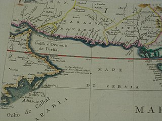
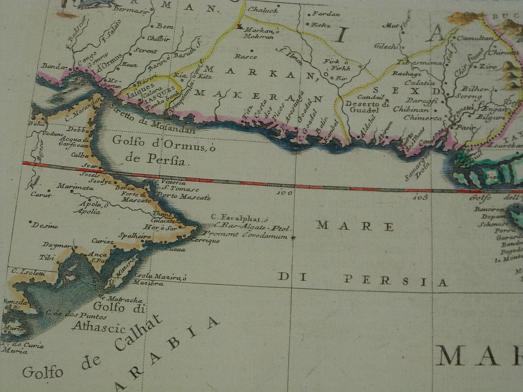
Slika:The western part of the Indian Ocean, by Vincenzo Maria Coronelli, 1693 from his system of global gores the Makran coast.jpg

Izvorna datoteka (1.600 × 1.200 točk, velikost datoteke: 381 KB, MIME-vrsta: image/jpeg)
Spodaj prikazane informacije so s tamkajšnje opisne strani.
Povzetek
| Opis |
INDIA, 1692 This map is accompanied by interesting and helpful commentary from the dealer, *regiomontanus*: Impero del Gran Mogol 60 x 45 cm copperplate engraving, 66 x 47.5 cm sheet size, modern hand colour, Venice, 1692 We are pleased to offer this scarce original map of the Mughal Empire (encompassing what is today northern India, Pakistan, Afghanistan, Nepal, Bangladesh, and Burma) at the height of its power by Vincenzo Coronelli (1650-1718) of Venice, a Franciscan friar who also served as Royal Geographer to Louis XIV of France. Perhaps best known for his magnificent globes, Coronelli produced over 400 maps throughout his long career and this scarce and important map is an example of his meticulous emphasis on detail and accuracy while still retaining charming baroque embellishments. In 1684 Coronelli founded the first modern geographical society - the Accademia Cosmografica degli Argonauti, which eventually attained a membership of over 200 cartographers and scholars throughout Europe. The basic cartography follows the traditional 17th century Dutch "Magni Mogolis Imperium" format of essentially identical maps issued by Hondius, Blaeu, Jansson and others which were in turn based on British East India Company charts including a survey by the British explorer William Baffin. However, Coronelli also draws on Venetian sources for extensive text entries regarding different cities and peoples of the region that provides a rich portrait of European understanding of the Mughal Empire during the long reign of Emperor Aurangzeb. Coronelli's bold engraving style, the large format and charming decorative elements - all accentuated here by hand colour work of the very highest calibre - have deservedly made this one of the most sought after antiquarian maps of the region and this example will make an elegant presentation if matted and framed. We begin our survey of the map with the handsome title cartouche featuring a martial theme - note "Cabul" (Kabul) in what is now Afghanistan: A separate dedication cartouche honours Venetian statesman Girolamo Correr (aka Corraro), a patron of Coronelli's geographic academy: Moving to the map itself we find the spurious Lake Chiang Mai or Lake Chiamay as the source for rough representations of the Yangtze, Mekong, Salween and Brahmaputra rivers - a fiction first reported by the Portuguese Antonio de Faria y Sousa in 1543. Coronelli's notation discusses seasonal, annual flooding: Mouths of the Ganges: Source of the Ganges - note variants of spelling for town names, with some listing as many as four: Gulf of Khambhat - to get a sense of map detail consider that the distance from Chittaurgarh (here shown as "Chitor") to Burhanpur (here shown as "Brampore") at lower right as seen in the enlarged photo below measures just 8.5 cm actual size: And people in the region near Kandahar are described as warlike: The western part of the Indian Ocean, by Vincenzo Maria Coronelli, 1693, from his system of *"global gores"*; with detailed scans of: *the cartouche*; *the Makran coast*; *the Gujarat coast*; *the northern Deccan*; *the south* "Mare L Indiae. This original Globe Gore map section - from Coronelli's 42in Globe - of India, Persia, Oman and the Maldives was published by Vincenzo Maria Coronelli (1650 - 1718) in the 1693 Venice edition of Libro dei Globi. Plate size: - 11 ½in x 11in (295mm x 280mm)." |
| Datum | med leti 1692 in 1693 |
| Vir | http://www.columbia.edu/itc/mealac/pritchett/00maplinks/mughal/miscmaps1600s/coronelli/coronelli.html |
| Avtor | Vincenzo Maria Coronelli |
Licenca
|
To delo je v javni domeni tudi v državah in na območjih, kjer trajajo avtorske pravice za časa avtorjevega življenja in še 70 let ali manj po tem.
| |
| Datoteka je bila prepoznana kot prosta omejitev po avtorskem pravu, vključno z vsemi povezanimi in sorodnimi pravicami. | |
Zgodovina datoteke
Kliknite datum in čas za ogled datoteke, ki je bila takrat naložena.
| Datum in čas | Sličica | Velikost | Uporabnik | Komentar | |
|---|---|---|---|---|---|
| trenutno | 18:45, 30. september 2017 | | 1.600 × 1.200 (381 KB) | Baddu676 |
Uporaba datoteke
Datoteka je del naslednjih 2 strani slovenske Wikipedije (strani drugih projektov niso navedene):
Globalna uporaba datoteke
To datoteko uporabljajo tudi naslednji vikiji:
- Uporaba na bn.wikipedia.org
- Uporaba na en.wikipedia.org
- Uporaba na es.wikipedia.org
- Uporaba na fa.wikipedia.org
- Uporaba na simple.wikipedia.org
- Uporaba na sr.wikipedia.org
- Uporaba na ur.wikipedia.org