Slika:Schlieffen Plan.jpg

Izvorna datoteka (963 × 745 točk, velikost datoteke: 732 KB, MIME-vrsta: image/jpeg)
Spodaj prikazane informacije so s tamkajšnje opisne strani.

|
File:Schlieffen Plan fr.svg je vektorska različica te datoteke. Kjer je primernejša, naj se uporablja namesto te rastrske slike.
File:Schlieffen Plan.jpg → File:Schlieffen Plan fr.svg
Več informacij o vektorski grafiki je na voljo na strani Commons:Transition to SVG. Na voljo so tudi informacije o podprtosti SVG-slik v programju MediaWiki. |
 |
| Opis |
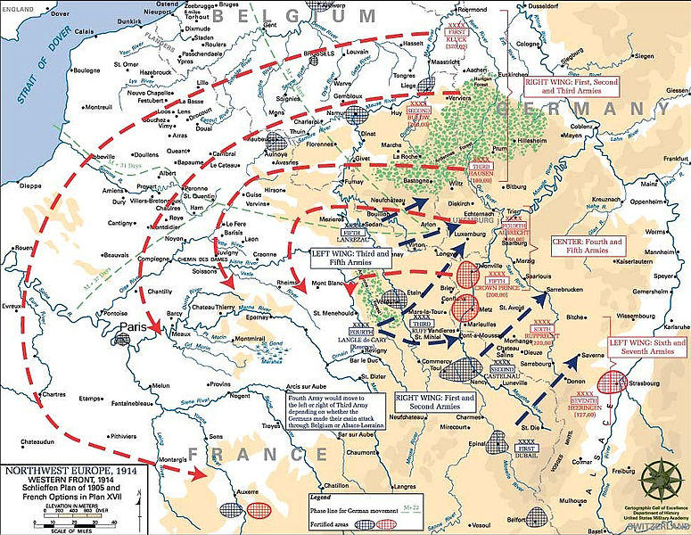
English: Schlieffen Plan
In 1938 the predecessors of what is today The Department of History at the United States Military Academy began developing a series of campaign atlases to aid in teaching cadets a course entitled, "History of the Military Art." Since then, the Department has produced over six atlases and more than one thousand maps, encompassing not only America’s wars but global conflicts as well. In keeping abreast with today's technology, the Department of History is providing these maps on the internet as part of the department's outreach program. The maps were created by the United States Military Academy’s Department of History and are the digital versions from the atlases printed by the United States Defense Printing Agency. We gratefully acknowledge the accomplishments of the department's former cartographer, Mr. Edward J. Krasnoborski, along with the works of our present cartographer, Mr. Frank Martini. Please be aware that these maps are large in file size and may require substantial download times. |
| Datum | 05/09/2008 |
| Vir | Westpoint.edu, WWI Atlas, Shlieffen Plan |
| Avtor | Tinodela |
| Druge različice |
|
This file is a work of a U.S. Army soldier or employee, taken or made as part of that person's official duties. As a work of the U.S. federal government, it is in the public domain in the United States.
|
 |
Derivative works
Izpeljana dela te datoteke: Schlieffen Plan.svg
Zgodovina datoteke
Kliknite datum in čas za ogled datoteke, ki je bila takrat naložena.
| Datum in čas | Sličica | Velikost | Uporabnik | Komentar | |
|---|---|---|---|---|---|
| trenutno | 13:43, 23. julij 2012 | | 963 × 745 (732 KB) | Soerfm | Paris |
| 13:58, 1. marec 2006 |  | 969 × 751 (273 KB) | W.wolny |
Uporaba datoteke
Datoteka je del naslednjih 2 strani slovenske Wikipedije (strani drugih projektov niso navedene):
Globalna uporaba datoteke
To datoteko uporabljajo tudi naslednji vikiji:
- Uporaba na ar.wikipedia.org
- Uporaba na be-tarask.wikipedia.org
- Uporaba na be.wikipedia.org
- Uporaba na bg.wikipedia.org
- Uporaba na ca.wikipedia.org
- Uporaba na cs.wikipedia.org
- Uporaba na da.wikipedia.org
- Uporaba na de.wikipedia.org
- Uporaba na de.wikibooks.org
- Uporaba na de.wikinews.org
- Uporaba na el.wikipedia.org
- Uporaba na en.wikipedia.org
- Uporaba na en.wikibooks.org
- Uporaba na fi.wikipedia.org
- Uporaba na fr.wikipedia.org
Oglejte si globalno uporabo te datoteke.