Slika:Polish and Lithuanian Conflict with Prussia. 1377-1435..png
Velikost tega predogleda: 696 × 600 točk. Druge ločljivosti: 279 × 240 točk | 557 × 480 točk | 968 × 834 točk.
Izvorna datoteka (968 × 834 točk, velikost datoteke: 182 KB, MIME-vrsta: image/png)
Spodaj prikazane informacije so s tamkajšnje opisne strani.
Povzetek
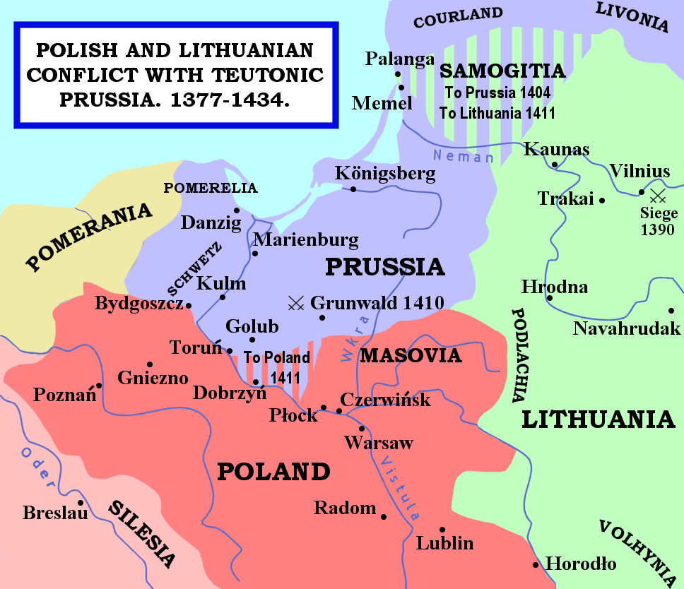
| Opis | The map shows the areas of conflict between Teutonic Prussia and Poland and Lithuania during the reigns of Jogaila (Władysław II Jagiełło) and Vytautas. The areas on the borders of Prussia and Poland were particularly disputed: towns often changed hands, and Dobrzyń Land (red-and-mauve stripes) was passed back and forward as a result of various deals, treaties, and battles. Samogitia (green-and-mauve stripes) was also strongly disputed between the Teutonic Order and Lithuania, because the Knights wished to link up with the Livonian Lands further north. After the Battle of Grunwald in 1410, a series of treaties established Polish control over Dobrzyń Land and Lithuanian control over Samogitia for good, marking the beginning of the Teutonic State's decline. |
| Datum | 29. januarja 2007 (izvirni datum naložitve) |
| Vir | Naveden ni noben strojno berljiv vir. Predpostavljeno je lastno delo (na podlagi izjav o avtorskih pravicah). |
| Avtor | No machine-readable author provided. Qp10qp assumed (based on copyright claims). |
Sources
- The map was outlined from this old German map: Image:Poland under Jagello.jpg.
Other references:
- The Times Concise Atlas of World History, Times Books, 1994, ISBN 0-7230-0674-1, p. 56.
- Lukowski, Jerzy and Hubert Zawadzki (2001). A Concise History of Poland. Cambridge: Cambridge University Press. ISBN 0-521-55917-0. Maps on p. 36-38.
- "Baltic Europe", in The New Cambridge Medieval History VI, ed. Michael Jones, Cambridge University Press, ISBN 0-521-36290-3. Map on p. 700.
Licenca
| Jaz, imetnik avtorskih pravic na tem delu, izročam to delo v javno domeno. To velja po vsem svetu. V nekaterih državah to pravno morda ni mogoče. Če je tako, Vsakomur dajem (v okviru zakonskih omejitev) brezpogojno pravico, da gradivo uporablja v kateri koli namen. |
Zgodovina datoteke
Kliknite datum in čas za ogled datoteke, ki je bila takrat naložena.
| Datum in čas | Sličica | Velikost | Uporabnik | Komentar | |
|---|---|---|---|---|---|
| trenutno | 01:22, 15. februar 2007 | | 968 × 834 (182 KB) | Qp10qp | |
| 09:05, 29. januar 2007 |  | 968 × 834 (182 KB) | Qp10qp | The map shows the areas of conflict between Teutonic Prussia and Poland and Lithuania during the reigns of Jogaila (Władysław II Jagiełło) and Vytautas. The areas on the borders of Prussia and Poland were particularly disputed: towns changed often cha |
Uporaba datoteke
Datoteka je del naslednjih 2 strani slovenske Wikipedije (strani drugih projektov niso navedene):
Globalna uporaba datoteke
To datoteko uporabljajo tudi naslednji vikiji:
- Uporaba na ar.wikipedia.org
- Uporaba na ast.wikipedia.org
- Uporaba na az.wikipedia.org
- Uporaba na da.wikipedia.org
- Uporaba na en.wikipedia.org
- Uporaba na es.wikipedia.org
- Uporaba na fr.wikipedia.org
- Uporaba na gl.wikipedia.org
- Uporaba na he.wikipedia.org
- Uporaba na hu.wikipedia.org
- Uporaba na id.wikipedia.org
- Uporaba na it.wikipedia.org
- Uporaba na ja.wikipedia.org
- Uporaba na lt.wikibooks.org
- Uporaba na pl.wikipedia.org
- Uporaba na pt.wikipedia.org
- Uporaba na tr.wikipedia.org
- Uporaba na uk.wikipedia.org
- Uporaba na vls.wikipedia.org
- Uporaba na www.wikidata.org
- Uporaba na zh.wikipedia.org