Slika:Nile River Delta at Night.JPG

Izvorna datoteka (4.256 × 2.832 točk, velikost datoteke: 2,05 MB, MIME-vrsta: image/jpeg)
Spodaj prikazane informacije so s tamkajšnje opisne strani.
Povzetek
| Opis |
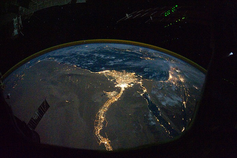
English: In this view of Egypt, we see a population almost completely concentrated along the Nile Valley, just a small percentage of the country’s land area. The Nile River and its delta look like a brilliant, long-stemmed flower in this astronaut photograph of the south-eastern Mediterranean Sea, as seen from the International Space Station. The Cairo metropolitan area forms a particularly bright base of the flower. The smaller cities and towns within the Nile Delta tend to be hard to see amidst the dense agricultural vegetation during the day. However, these settled areas and the connecting roads between them become clearly visible at night. Likewise, urbanized regions and infrastructure along the Nile River becomes apparent.
Another brightly lit region is visible along the eastern coastline of the Mediterranean—the Tel-Aviv metropolitan area in Israel (image right). To the east of Tel-Aviv lies Amman, Jordan. The two major water bodies that define the western and eastern coastlines of the Sinai Peninsula—the Gulf of Suez and the Gulf of Aqaba—are outlined by lights along their coastlines (image lower right). The city lights of Paphos, Limassol, Larnaca, and Nicosia are visible on the island of Cyprus (image top). Scattered blue-grey clouds cover the Mediterranean Sea and the Sinai, while much of north-eastern Africa is cloud-free. A thin yellow-brown band tracing the Earth’s curvature at image top is air-glow, a faint band of light emission that results from the interaction of atmospheric atoms and molecules with solar radiation at approximately 100 kilometres altitude. |
| Datum | |
| Vir | NASA Earth Observatory |
| Avtor | ISS Expedition 25 crew |
| Druge različice |
Izpeljana dela te datoteke: Nile River Delta at Night cropped.JPG Also see http://earthobservatory.nasa.gov/IOTD/view.php?id=46820&src=eoa-iotd for annotated version, with features identified. |
| Lokacija fotoaparata | | Ta in druge slike po lokaciji: OpenStreetMap |
|---|
To sliko ali ta video je katalogiziral Johnson Space Center Nacionalne uprave za aeronavtiko in vesolje (NASA) Združenih držav Amerike pod oznako fotografije: ISS025-E-9858. Ta predloga ne označuje avtorskopravnega stanja dela. Ob njej mora stati tudi običajna oznaka avtorskopravnega stanja gradiva. Glejte Commons:Navedba licence. Drugi jeziki:
|
Image acquired with a Nikon D3S digital camera using a 16 mm lens, and is provided by the ISS Crew Earth Observations experiment and Image Science & Analysis Laboratory, Johnson Space Center.
Licenca
| Ta datoteka je v javni domeni, ker jo je izdelala izključno NASA. Avtorskopravna politika NASE pravi, da »Gradivo NASE ni zaščiteno z avtorskimi pravicami, razen če je rečeno drugače.« (glej Template:PD-USGov, stran z avtorskopravno politiko NASE ali Politiko uporabe slik JPL.) | ||
 |
Opozorila:
|
| Annotations | This image is annotated: View the annotations at Commons |
Zgodovina datoteke
Kliknite datum in čas za ogled datoteke, ki je bila takrat naložena.
| Datum in čas | Sličica | Velikost | Uporabnik | Komentar | |
|---|---|---|---|---|---|
| trenutno | 14:51, 8. november 2010 | | 4.256 × 2.832 (2,05 MB) | Originalwana | {{Information |Description={{en|1=In this view of Egypt, we see a population almost completely concentrated along the Nile Valley, just a small percentage of the country’s land area. The Nile River and its delta look like a brilliant, long-stemmed flow |
Uporaba datoteke
Datoteka je del naslednje 1 strani slovenske Wikipedije (strani drugih projektov niso navedene):
Globalna uporaba datoteke
To datoteko uporabljajo tudi naslednji vikiji:
- Uporaba na af.wikipedia.org
- Uporaba na arz.wikipedia.org
- Uporaba na av.wikipedia.org
- Uporaba na bg.wikipedia.org
- Uporaba na bs.wikipedia.org
- Uporaba na cs.wikipedia.org
- Uporaba na el.wikipedia.org
- Uporaba na en.wikipedia.org
- Uporaba na en.wiktionary.org
- Uporaba na es.wikipedia.org
- Uporaba na ha.wikipedia.org
- Uporaba na he.wikipedia.org
- Uporaba na incubator.wikimedia.org
- Uporaba na ln.wikipedia.org
- Uporaba na ml.wikipedia.org
- Uporaba na no.wikipedia.org
- Uporaba na sd.wikipedia.org
- Uporaba na sk.wikipedia.org
- Uporaba na sq.wikipedia.org
- Uporaba na sq.wikiquote.org
- Uporaba na sr.wikipedia.org
- Uporaba na sv.wikipedia.org
- Uporaba na ta.wikipedia.org
- Uporaba na th.wikipedia.org
- Uporaba na tr.wikipedia.org
- Uporaba na uk.wikipedia.org
- Uporaba na ur.wikipedia.org
- Uporaba na vi.wikipedia.org