Slika:Nansen Fram Map.png
Višja ločljivost ni na voljo.
Nansen_Fram_Map.png (800 × 479 točk, velikost datoteke: 195 KB, MIME-vrsta: image/png)
Spodaj prikazane informacije so s tamkajšnje opisne strani.
Povzetek
| Opis |
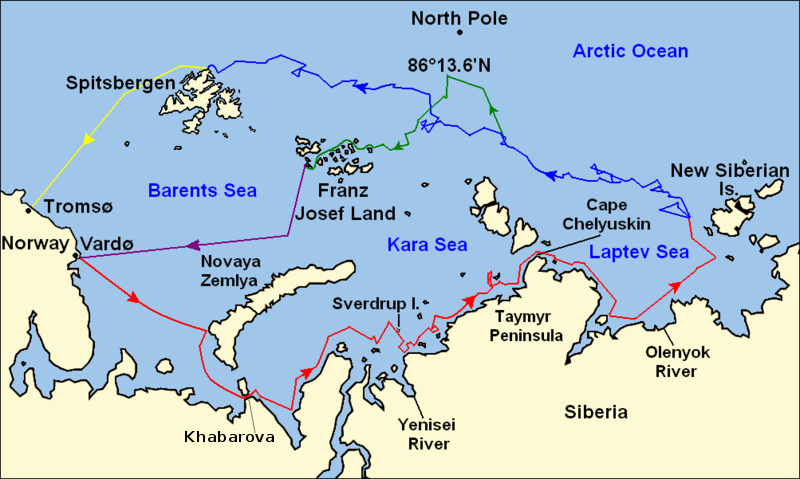
Map of the Arctic Ocean showing the routes taken during the 1893–96 Nansen's Fram expedition: Fram's route eastward from Vardø to the Siberian coast, turning north at the New Siberian Islands to enter the pack ice. July – September 1893 Fram's drift in the ice from the New Siberian Islands, north and west to Spitsbergen, September 1893 – August 1896 Nansen and Johansen's march to Farthest North, 86°20'N, and their subsequent retreat to Cape Flora in Franz Josef Land. February 1895 – June 1896 Nansen and Johansen's return to Vardø from Cape Flora, August 1896 Fram's voyage from Spitsbergen to Tromsø, August 1896 |
| Datum | |
| Vir | Base map of European and Asian mainland is from File:Map of Russian Subjects old.png by User:fremantleboy, map of Spitsbergen (Svalbard) is based on File:Bjornoya map.png by User:NormanEinstein. Voyage traces based on this map from The Northern Lights Route. First published in Nansen, Fridtjof: Farthest North, Constable & Co, London 1897 |
| Avtor | User:fremantleboy, User:NormanEinstein, Ruhrfisch |
| Dovoljenje (Nadaljnja uporaba datoteke) |
GFDL, CC-BY-SA |
| Druge različice |
|


|
File:Nansen Fram Map.svg je vektorska različica te datoteke. Kjer je primernejša, naj se uporablja namesto te rastrske slike.
File:Nansen Fram Map.png → File:Nansen Fram Map.svg
Več informacij o vektorski grafiki je na voljo na strani Commons:Transition to SVG. Na voljo so tudi informacije o podprtosti SVG-slik v programju MediaWiki. |
 |
Licenca
Jaz, imetnik avtorskih pravic na tem delu, ga s tem objavljam pod naslednjimi licencami:

|
Ta dokument je dovoljeno kopirati, razširjati in/ali spreminjati pod pogoji Licence GNU za prosto dokumentacijo, različica 1.2 ali katera koli poznejša, ki jo je objavila ustanova Free Software Foundation; brez nespremenljivih delov ter brez besedil na sprednji ali zadnji platnici. Kopija licence je vključena v razdelek Licenca GNU za prosto dokumentacijo. |
This file is licensed under the Creative Commons Attribution-Share Alike 4.0 International, 3.0 Unported, 2.5 Generic, 2.0 Generic and 1.0 Generic license.
- Dovoljeno vam je:
- deljenje – reproducirati, distribuirati in javno priobčevati delo
- predelava – predelati delo
- Pod naslednjimi pogoji:
- priznanje avtorstva – Navesti morate ustrezno avtorstvo, povezavo do licence in morebitne spremembe. To lahko storite na kakršen koli primeren način, vendar ne na način, ki bi nakazoval, da dajalec licence podpira vas ali vašo uporabo dela.
- deljenje pod enakimi pogoji – Če boste to vsebino predelali, preoblikovali ali uporabili kot izhodišče za drugo delo, morate svoj prispevek distribuirati pod enako ali združljivo licenco, kot jo ima izvirnik.
Izberete lahko licenco po svoji izbiri.
Zgodovina datoteke
Kliknite datum in čas za ogled datoteke, ki je bila takrat naložena.
| Datum in čas | Sličica | Velikost | Uporabnik | Komentar | |
|---|---|---|---|---|---|
| trenutno | 14:16, 8. maj 2011 | | 800 × 479 (195 KB) | Chris55 | Added [http://website.lineone.net/~polar.publishing/khabarova.htm Khabarova] where they picked up the dogs. |
| 17:50, 21. oktober 2009 |  | 1.003 × 601 (78 KB) | Ruhrfisch | Make arrowheads less triangular (indentations at rear) | |
| 17:23, 21. oktober 2009 |  | 1.003 × 601 (78 KB) | Ruhrfisch | Add arrowheads per FAC | |
| 20:50, 20. oktober 2009 |  | 1.003 × 601 (78 KB) | Ruhrfisch | Make magenta line purple | |
| 15:36, 11. oktober 2009 |  | 1.003 × 601 (78 KB) | Ruhrfisch | Yellow line for orange, some labels smaller, Farthest North replaced with actual figure, all other info the same | |
| 05:08, 11. oktober 2009 |  | 1.003 × 601 (80 KB) | Ruhrfisch | Darker green for that line, all other information is the same | |
| 04:46, 11. oktober 2009 |  | 1.003 × 601 (80 KB) | Ruhrfisch | Added last two lines for ice voyages, added last labels, all other information the same. | |
| 21:30, 9. oktober 2009 |  | 1.003 × 601 (73 KB) | Ruhrfisch | Add labels, two more voyage lines, all other information is the same | |
| 18:12, 9. oktober 2009 |  | 1.003 × 601 (57 KB) | Ruhrfisch | == Summary == {{Information |Description = Map of the Arctic Ocean showing the path of Nansen's Fram expedition 1893 to 1896 |Source = Base map of European mainland is from [[:File:Map of Russian Subjects old.png] |
Uporaba datoteke
Datoteka je del naslednje 1 strani slovenske Wikipedije (strani drugih projektov niso navedene):
Globalna uporaba datoteke
To datoteko uporabljajo tudi naslednji vikiji:
- Uporaba na bg.wikipedia.org
- Uporaba na en.wikipedia.org
- Uporaba na es.wikipedia.org
- Uporaba na fr.wikipedia.org
- Uporaba na hr.wikipedia.org
- Uporaba na id.wikipedia.org
- Uporaba na ja.wikipedia.org
- Uporaba na pt.wikipedia.org