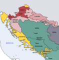
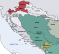
Slika:Map of the Kingdom of Croatia (1868).png
Map_of_the_Kingdom_of_Croatia_(1868).png (542 × 502 točk, velikost datoteke: 40 KB, MIME-vrsta: image/png)
Zgodovina datoteke
Kliknite datum in čas za ogled datoteke, ki je bila takrat naložena.
| Datum in čas | Sličica | Velikost | Uporabnik | Komentar | |
|---|---|---|---|---|---|
| trenutno | 20:35, 10. november 2022 |  | 542 × 502 (40 KB) | CarRadovan | Reverted to version as of 22:47, 17 December 2016 (UTC) |
| 06:43, 12. februar 2017 |  | 542 × 552 (39 KB) | Ceha | Reverted to version as of 10:26, 17 December 2016 (UTC) as discussed before | |
| 00:47, 18. december 2016 |  | 542 × 502 (40 KB) | Lilic | Reverted to version as of 11:51, 13 October 2009 (UTC) reverting to author's original map, as it is in fact better | |
| 12:26, 17. december 2016 |  | 542 × 552 (39 KB) | Ceha | Showed croatian aspirations (pale orange), marked Slavonia as area which sended representatives in croatian parliament, as well as military borders which were part (at least in it's names) of Croatia and Slavonia. | |
| 13:51, 13. oktober 2009 |  | 542 × 502 (40 KB) | DIREKTOR | {{Information |Description={{en|1=Map of the Kingdom of Croatia (red) in late 1867 and early 1868 (before the Croatian-Hungarian Nagodba and the establishment of the Kingdom of Croatia-Slavonia). The Kingdom of Slavonia was independent of Croatia at the t | |
| 13:49, 13. oktober 2009 |  | 542 × 502 (40 KB) | DIREKTOR | {{Information |Description={{en|1=Map of the Kingdom of Croatia (red) in late 1867 and early 1868 (before the Croatian-Hungarian Nagodba and the establishment of the Kingdom of Croatia-Slavonia). The Kingdom of Slavonia was independent of Croatia at the t | |
| 13:45, 13. oktober 2009 |  | 542 × 502 (40 KB) | DIREKTOR | {{Information |Description={{en|1=Map of the Kingdom of Croatia (red) in late 1867 and early 1868 (before the Croatian-Hungarian Nagodba and the establishment of the Kingdom of Croatia-Slavonia). The Kingdom of Slavonia was independent of Croatia at the t | |
| 12:04, 11. oktober 2009 |  | 542 × 502 (39 KB) | DIREKTOR | {{Information |Description={{en|1=Map of the Kingdom of Croatia (red) in late 1867 and early 1868 (before the Croatian-Hungarian Nagodba and the establishment of the Kingdom of Croatia-Slavonia). The Kingdom of Slavonia was independent of Croatia at the t | |
| 18:39, 8. oktober 2009 |  | 542 × 502 (38 KB) | DIREKTOR | {{Information |Description={{en|1=Map of the Kingdom of Croatia (red) in late 1867 and early 1868 (before the Croatian-Hungarian Nagodba and the establishment of the Kingdom of Croatia-Slavonia). The Kingdom of Slavonia was independent of Croatia at the t | |
| 14:47, 8. oktober 2009 |  | 542 × 502 (38 KB) | DIREKTOR | {{Information |Description={{en|1=Map of the Kingdom of Croatia (red) in late 1867 and early 1868 (before the Croatian-Hungarian Nagodba and the establishment of the Kingdom of Croatia-Slavonia). The Kingdom of Slavonia was independent of Croatia at the t |
Uporaba datoteke
Datoteka je del naslednje 1 strani slovenske Wikipedije (strani drugih projektov niso navedene):
Globalna uporaba datoteke
To datoteko uporabljajo tudi naslednji vikiji:
- Uporaba na azb.wikipedia.org
- Uporaba na bg.wikipedia.org
- Uporaba na bs.wikipedia.org
- Uporaba na cs.wikipedia.org
- Uporaba na el.wikipedia.org
- Uporaba na en.wikipedia.org
- Uporaba na es.wikipedia.org
- Uporaba na et.wikipedia.org
- Uporaba na eu.wikipedia.org
- Uporaba na fi.wikipedia.org
- Uporaba na hu.wikipedia.org
- Uporaba na it.wikipedia.org
- Uporaba na ja.wikipedia.org
- Uporaba na ko.wikipedia.org
- Uporaba na lv.wikipedia.org
- Uporaba na mk.wikipedia.org
- Uporaba na nl.wikipedia.org
- Uporaba na pt.wikipedia.org
- Uporaba na ro.wikipedia.org
- Uporaba na ru.wikipedia.org
- Uporaba na sh.wikipedia.org
- Uporaba na sr.wikipedia.org
- Uporaba na sv.wikipedia.org
- Uporaba na tr.wikipedia.org
- Uporaba na uk.wikipedia.org
- Uporaba na www.wikidata.org

