Slika:Map of Russia - Far Eastern Federal District (2018 composition).svg

Velikost tega predogleda PNG datoteke SVG: 800 × 462 točk. Druge ločljivosti: 320 × 185 točk | 640 × 369 točk | 1.024 × 591 točk | 1.280 × 738 točk | 2.560 × 1.477 točk | 1.092 × 630 točk.
Izvorna datoteka (Datoteka SVG, nominalno 1.092 × 630 pikslov, velikost datoteke: 61 KB)
Spodaj prikazane informacije so s tamkajšnje opisne strani.
.svg)

|
The boundaries on this map show the de facto situation. This is just one of several different views on the subject (see COM:NPOV). |
Povzetek
| Opis |
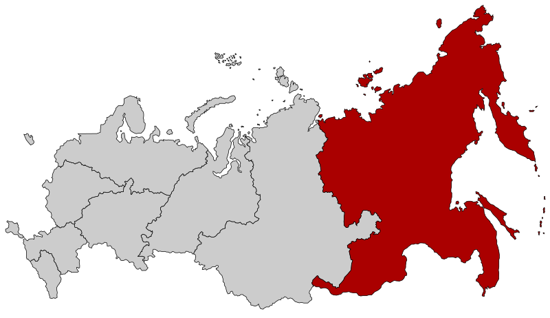
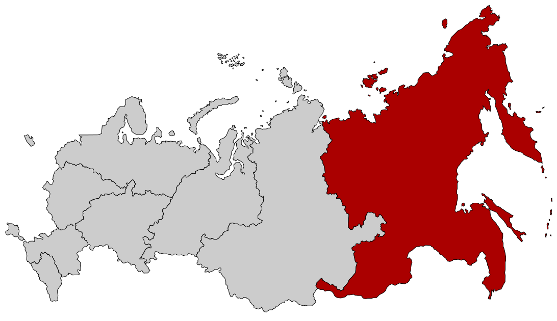
English: Map Russia highlighting the Far Eastern Federal district as of 2018-11-03. Español: Ubicación del Distrito Federal de Lejano Oriente en la Federación Rusa Русский: Дальневосточный федеральный округ |
| Datum | (UTC) |
| Vir |
Ta datoteka je izpeljana iz: |
| Avtor |
| Ta slika je digitalno obdelana. Opravljene so bile naslednje spremembe: Added Buryatia and Zabaykalsky Krai. Izvirnik je na voljo tukaj: Map of Russia - Far Eastern Federal District.svg. Spremembe je opravil uporabnik Seryo93.
|
Licenca
Datoteka je objavljena pod licenco Creative Commons Priznanje avtorstva-Deljenje pod enakimi pogoji 2.5 Generična.
- Dovoljeno vam je:
- deljenje – reproducirati, distribuirati in javno priobčevati delo
- predelava – predelati delo
- Pod naslednjimi pogoji:
- priznanje avtorstva – Navesti morate ustrezno avtorstvo, povezavo do licence in morebitne spremembe. To lahko storite na kakršen koli primeren način, vendar ne na način, ki bi nakazoval, da dajalec licence podpira vas ali vašo uporabo dela.
- deljenje pod enakimi pogoji – Če boste to vsebino predelali, preoblikovali ali uporabili kot izhodišče za drugo delo, morate svoj prispevek distribuirati pod enako ali združljivo licenco, kot jo ima izvirnik.
Izvorni dnevniški zapis naložitve
This image is a derivative work of the following images:
- File:Map of Russia - Far Eastern Federal District.svg licensed with Cc-by-sa-2.5
- 2018-11-04T19:12:00Z Seryo93 1092x630 (97483 Bytes) Reverted to version as of 14:21, 10 March 2015 (UTC): will upload separately
- 2018-11-04T19:11:17Z Seryo93 1092x630 (62312 Bytes) cleanup
- 2018-11-04T19:04:20Z Seryo93 1092x630 (287327 Bytes) Update from [[:File:Map_of_Russian_districts,_2018-11-04.svg]]
- 2015-03-10T14:21:00Z Knyaz-1988 1092x630 (97483 Bytes) Reverted to version as of 22:12, 3 November 2014
- 2014-11-04T01:32:51Z Fry1989 1092x630 (120531 Bytes) NPOV issue.
- 2014-11-03T22:12:44Z Knyaz-1988 1092x630 (97483 Bytes) New version
- 2010-01-22T20:29:49Z Denhud 1092x630 (120531 Bytes) On 2010-01-19 Southern Federal District split in two, with its former southern territories forming new North Caucasian Federal District.
- 2010-01-21T22:25:25Z Denhud 1092x630 (120531 Bytes) On 2010-01-19 Southern Federal District split in two, with its former southern territories forming new North Caucasian Federal District.
- 2008-03-03T23:36:42Z Lokal Profil 1092x630 (114976 Bytes) {{Information |Description=Map Russia highlighting the Far Eastern [[:en:Federal districts of Russia|Federal districts]]. |Source=Based on [[:Image:Map of Russian subjects, 2008-03-01.svg|Map of Russian subjects, 2008-03-01.s
- File:Map of Russian districts, 2018-11-04.svg licensed with Cc-by-sa-2.5
Uploaded with derivativeFX
Zgodovina datoteke
Kliknite datum in čas za ogled datoteke, ki je bila takrat naložena.
| Datum in čas | Sličica | Velikost | Uporabnik | Komentar | |
|---|---|---|---|---|---|
| trenutno | 21:15, 4. november 2018 | | 1.092 × 630 (61 KB) | Seryo93 | == {{int:filedesc}} == {{Information |Description={{en|Map Russia highlighting the '''Far Eastern Federal district''' as of 2018-11-03.}} {{es|Ubicación del Distrito Federal de Lejano Oriente en la Federación Rusa}} {{Ru|Дальневосточный федеральный округ}} |Source={{Derived from|Map of Russia - Far Eastern Federal District.svg|Map of Russian districts, 2018-11-04.svg|display=50}} |Date=2018-11-04 19:14 (UTC) |Author=* [[:File:Map of Russia - Far Eastern Fed... |
Uporaba datoteke
Datoteka je del naslednjih 2 strani slovenske Wikipedije (strani drugih projektov niso navedene):
Globalna uporaba datoteke
To datoteko uporabljajo tudi naslednji vikiji:
- Uporaba na ar.wikipedia.org
- Uporaba na ast.wikipedia.org
- Uporaba na az.wikipedia.org
- Uporaba na be-tarask.wikipedia.org
- Uporaba na ca.wikipedia.org
- Uporaba na cs.wikipedia.org
- Uporaba na cv.wikipedia.org
- Uporaba na el.wikipedia.org
- Uporaba na en.wikipedia.org
- Russian Far East
- Far Eastern Federal District
- Category:Russian Far East
- User:Paukrus
- User:Paukrus/Userbox
- User:Paukrus/Userbox/Russian Far East
- User:Profwill
- User:Glucke
- Category:Geography of the Russian Far East
- Category:Landforms of the Russian Far East
- User:Antanaklasis
- Category:Far Eastern Federal District
- User:Weneedwikipedia
- Wikipedia:Userboxes/Location/Russia
- User:Dikivan2000
- Uporaba na en.wikinews.org
- Uporaba na eo.wikipedia.org
- Uporaba na et.wikipedia.org
- Uporaba na fi.wikipedia.org
Oglejte si globalno uporabo te datoteke.
.svg)
.svg)