Slika:Map of Naqsh-e Rostam.jpg
Višja ločljivost ni na voljo.
Map_of_Naqsh-e_Rostam.jpg (717 × 579 točk, velikost datoteke: 179 KB, MIME-vrsta: image/jpeg)
Spodaj prikazane informacije so s tamkajšnje opisne strani.
Povzetek
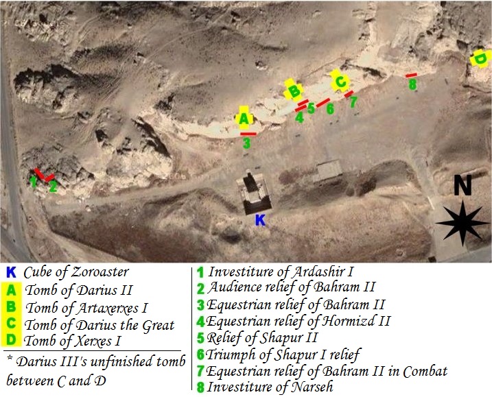
| Opis | map of archeological site of Naqsh-e Rostam (Iran, fars Province, city of Marvdasht) |
| Datum | |
| Vir | Own work using NASA's satellite picture of the place and an artifact sheme according to belgium archeologist Louis Vanden Berghe. |
| Avtor | Pentocelo |
| Druge različice | with french legends Image:Map of Naqsh-e Rostam (fr).jpg |
.jpg)
Licenca
| Jaz, imetnik avtorskih pravic na tem delu, izročam to delo v javno domeno. To velja po vsem svetu. V nekaterih državah to pravno morda ni mogoče. Če je tako, Vsakomur dajem (v okviru zakonskih omejitev) brezpogojno pravico, da gradivo uporablja v kateri koli namen. |
Zgodovina datoteke
Kliknite datum in čas za ogled datoteke, ki je bila takrat naložena.
| Datum in čas | Sličica | Velikost | Uporabnik | Komentar | |
|---|---|---|---|---|---|
| trenutno | 06:56, 27. februar 2011 | | 717 × 579 (179 KB) | Dr. Persi | I took this file from the original work done by the User Pentocelo. This is his original work and therefore the credit belongs to him. He however uploaded the file as no copyright, enabling me to improve his original version. He has created two versions o |
| 21:58, 6. februar 2008 |  | 717 × 579 (75 KB) | Pentocelo~commonswiki | == Description == {{Information |Description= map of archeological site of Naqsh-e Rostam (Iran, fars Province, city of Marvdasht) |Source= Own work using NASA's satellite picture of the place and an artifact sheme according to belgium archeologist Louis | |
| 21:26, 6. februar 2008 |  | 721 × 624 (83 KB) | Pentocelo~commonswiki | {{Information |Description= map of archeological site of Naqsh-e Rostam (Iran, fars Province, city of Marvdasht) |Source= Own work using NASA's satellite picture of the place and an artifact sheme according to belgium archeologist Louis Vanden Berghe. |Da |
Uporaba datoteke
Datoteka je del naslednje 1 strani slovenske Wikipedije (strani drugih projektov niso navedene):
Globalna uporaba datoteke
To datoteko uporabljajo tudi naslednji vikiji:
- Uporaba na ca.wikipedia.org
- Uporaba na de.wikivoyage.org
- Uporaba na en.wikipedia.org
- Uporaba na es.wikipedia.org
- Uporaba na it.wikipedia.org
- Uporaba na vi.wikipedia.org