Slika:Majuro Satellite.PNG

Velikost tega predogleda: 800 × 416 točk. Druge ločljivosti: 320 × 167 točk | 640 × 333 točk | 1.024 × 533 točk | 1.918 × 998 točk.
Izvorna datoteka (1.918 × 998 točk, velikost datoteke: 5,49 MB, MIME-vrsta: image/png)
Spodaj prikazane informacije so s tamkajšnje opisne strani.
Povzetek
| Opis |
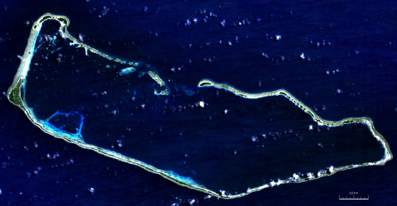
English: visible color satellite image of Majuro Atoll, Marshall Islands, Pacific Ocean |
| Datum | |
| Vir | NASA World Wind Screenshot (visible color) |
| Avtor | NASA |
Licenca
| This image is in the public domain because it is a screenshot from NASA’s globe software World Wind using a public domain layer, such as Blue Marble, MODIS, Landsat, SRTM, USGS or GLOBE.
|
 |
Zgodovina datoteke
Kliknite datum in čas za ogled datoteke, ki je bila takrat naložena.
| Datum in čas | Sličica | Velikost | Uporabnik | Komentar | |
|---|---|---|---|---|---|
| trenutno | 22:17, 7. avgust 2011 | | 1.918 × 998 (5,49 MB) | Ratzer | {{Information |Description ={{en|1=true color satellite image of Majuro Atoll, Marshall Islands, Pacific Ocean}} |Source =NASA World Wind Screenshot (true color) |Author =NASA |Date =2000 |Permission = |other_versions = }} |
Uporaba datoteke
Datoteka je del naslednje 1 strani slovenske Wikipedije (strani drugih projektov niso navedene):
Globalna uporaba datoteke
To datoteko uporabljajo tudi naslednji vikiji:
- Uporaba na be.wikipedia.org
- Uporaba na bn.wikipedia.org
- Uporaba na ceb.wikipedia.org
- Uporaba na de.wikipedia.org
- Uporaba na en.wikipedia.org
- Uporaba na eo.wikipedia.org
- Uporaba na es.wikipedia.org
- Uporaba na fi.wikipedia.org
- Uporaba na fr.wikipedia.org
- Uporaba na gn.wikipedia.org
- Uporaba na he.wikipedia.org
- Uporaba na hi.wikipedia.org
- Uporaba na id.wikipedia.org
- Uporaba na ja.wikipedia.org
- Uporaba na lt.wikipedia.org
- Uporaba na lv.wikipedia.org
- Uporaba na ml.wikipedia.org
- Uporaba na nl.wikipedia.org
- Uporaba na pl.wikipedia.org
- Uporaba na sat.wikipedia.org
- Uporaba na sd.wikipedia.org
- Uporaba na sh.wikipedia.org
- Uporaba na sr.wikipedia.org
- Uporaba na ur.wikipedia.org
- Uporaba na vep.wikipedia.org
- Uporaba na www.wikidata.org
- Uporaba na xmf.wikipedia.org
- Uporaba na zh.wikivoyage.org