Slika:MLS Azimuth Guidance.jpg

Višja ločljivost ni na voljo.
MLS_Azimuth_Guidance.jpg (640 × 480 točk, velikost datoteke: 54 KB, MIME-vrsta: image/jpeg)
Spodaj prikazane informacije so s tamkajšnje opisne strani.
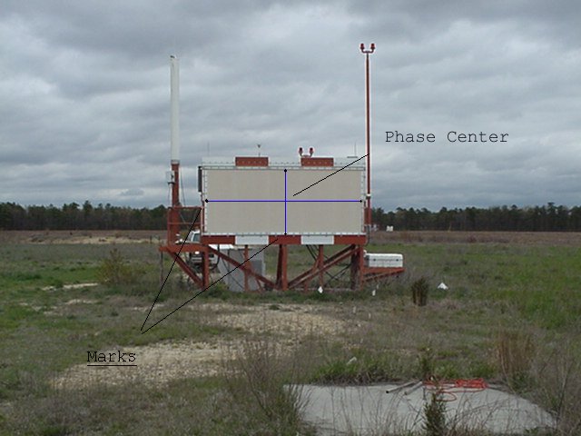
| Opis | MLS Azimuth Guidance. MLS-AZ Horizontal and Vertical Survey Point:phase center | |||
| Datum | neznan datum | |||
| Vir | Mlsaz1.jpg from http://www.ngs.noaa.gov/AERO/navimages/cmanual_mls.html | |||
| Avtor | USGS | |||
| Dovoljenje (Nadaljnja uporaba datoteke) |
|
Zgodovina datoteke
Kliknite datum in čas za ogled datoteke, ki je bila takrat naložena.
| Datum in čas | Sličica | Velikost | Uporabnik | Komentar | |
|---|---|---|---|---|---|
| trenutno | 02:37, 8. november 2006 | | 640 × 480 (54 KB) | Dual Freq | {{Information |Description=MLS Azimuth Guidance. MLS-AZ Horizontal and Vertical Survey Point:phase center |Source=[http://www.ngs.noaa.gov/AERO/navimages/mlsaz1.jpg Mlsaz1.jpg] from http://www.ngs.noaa.gov/AERO/navimages/cmanual_mls.html |Date=Unknown |A |
Uporaba datoteke
Datoteka je del naslednje 1 strani slovenske Wikipedije (strani drugih projektov niso navedene):
Globalna uporaba datoteke
To datoteko uporabljajo tudi naslednji vikiji:
- Uporaba na ar.wikipedia.org
- Uporaba na de.wikipedia.org
- Uporaba na en.wikipedia.org
- Uporaba na ja.wikipedia.org
- Uporaba na pl.wikipedia.org
- Uporaba na ru.wikipedia.org