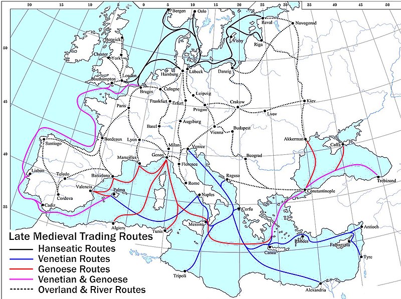
Slika:Late Medieval Trade Routes.jpg

Velikost tega predogleda: 800 × 597 točk. Druge ločljivosti: 320 × 239 točk | 640 × 478 točk | 1.024 × 765 točk | 1.280 × 956 točk | 1.457 × 1.088 točk.
Izvorna datoteka (1.457 × 1.088 točk, velikost datoteke: 372 KB, MIME-vrsta: image/jpeg)
Zgodovina datoteke
Kliknite datum in čas za ogled datoteke, ki je bila takrat naložena.
| Datum in čas | Sličica | Velikost | Uporabnik | Komentar | |
|---|---|---|---|---|---|
| trenutno | 22:46, 18. maj 2022 |  | 1.457 × 1.088 (372 KB) | Richard2s | Clearer key for map |
| 22:25, 23. januar 2011 |  | 853 × 544 (453 KB) | Micsha~commonswiki | Includes map key on the map | |
| 17:55, 28. marec 2008 |  | 1.817 × 1.120 (487 KB) | Lampman | {{Information |Description=Map showing the main trade routes of late medieval Europe. The black lines show the routes of the Hanseatic League, the blue Venetian and the red Genoese routes. Purple lines are routes used by both the Venetians and the Genoese |
Uporaba datoteke
Datoteka je del naslednje 1 strani slovenske Wikipedije (strani drugih projektov niso navedene):
Globalna uporaba datoteke
To datoteko uporabljajo tudi naslednji vikiji:
- Uporaba na ar.wikipedia.org
- Uporaba na be-tarask.wikipedia.org
- Uporaba na bg.wikipedia.org
- Uporaba na ca.wikipedia.org
- Uporaba na da.wikipedia.org
- Uporaba na el.wikipedia.org
- Uporaba na en.wikipedia.org
- Uporaba na es.wikipedia.org
- Uporaba na et.wikipedia.org
- Uporaba na fr.wikipedia.org
- Uporaba na he.wikipedia.org
- Uporaba na hy.wikipedia.org
- Uporaba na it.wikipedia.org
- Uporaba na ja.wikipedia.org
- Uporaba na mk.wikipedia.org
- Uporaba na nl.wikipedia.org
- Uporaba na pl.wikipedia.org
- Uporaba na pt.wikipedia.org
- Uporaba na rm.wikipedia.org
- Uporaba na sh.wikipedia.org
- Uporaba na sq.wikipedia.org
- Uporaba na uk.wikipedia.org
Oglejte si globalno uporabo te datoteke.


