Slika:Istria Croatian Adriatic.png
Istria_Croatian_Adriatic.png (596 × 559 točk, velikost datoteke: 84 KB, MIME-vrsta: image/png)
Spodaj prikazane informacije so s tamkajšnje opisne strani.
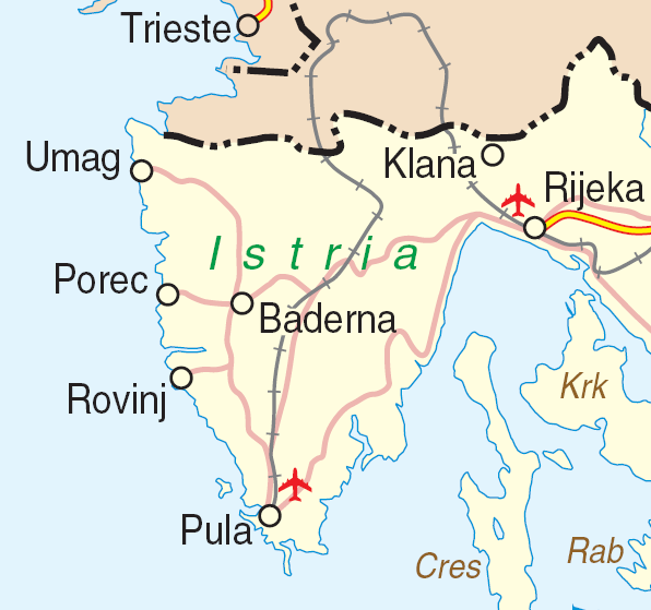
| Opis | Map of Istria, Croatia | |||
| Datum | ||||
| Vir | http://www.un.org/Depts/Cartographic/map/profile/croatia.pdf | |||
| Avtor | Department of Peacekeeping Operations Cartographic Section | |||
| Dovoljenje (Nadaljnja uporaba datoteke) |
|

Zgodovina datoteke
Kliknite datum in čas za ogled datoteke, ki je bila takrat naložena.
| Datum in čas | Sličica | Velikost | Uporabnik | Komentar | |
|---|---|---|---|---|---|
| trenutno | 18:59, 23. marec 2007 | | 596 × 559 (84 KB) | Minestrone | {{Information| |Description=Map of Istria, Croatia |Source=http://www.un.org/Depts/Cartographic/map/profile/croatia.pdf |Date=June, 2004 |Author=Department of Peacekeeping Operations Cartographic Section |Permission={{UN map}} }} |
Uporaba datoteke
Datoteka ni del nobene strani slovenske Wikipedije.
Globalna uporaba datoteke
To datoteko uporabljajo tudi naslednji vikiji:
- Uporaba na bs.wikipedia.org
- Uporaba na ceb.wikipedia.org
- Uporaba na de.wikipedia.org
- Uporaba na en.wikipedia.org
- Uporaba na hr.wikipedia.org
- Uporaba na it.wikivoyage.org
- Uporaba na www.wikidata.org