Slika:Iraq.A2003060.0750.500m.jpg

Velikost tega predogleda: 461 × 599 točk. Druge ločljivosti: 184 × 240 točk | 369 × 480 točk | 591 × 768 točk | 788 × 1.024 točk | 2.000 × 2.600 točk.
Izvorna datoteka (2.000 × 2.600 točk, velikost datoteke: 1.012 KB, MIME-vrsta: image/jpeg)
Spodaj prikazane informacije so s tamkajšnje opisne strani.
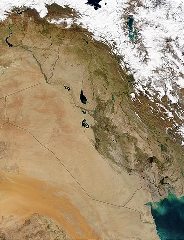
This Moderate Resolution Imaging Spectroradiometer (MODIS) image from March 1, 2003, shows numerous oil well flares (the burning off of combustible gases associated with oil) in southern Iraq (center). The way the active hot spots, marked in red, line up almost vertically suggests they are along a pipeline. Meanwhile, hot spots in southern Iran (right) are likely agricultural fires.
http://visibleearth.nasa.gov/view_rec.php?id=5166
| Ta datoteka je v javni domeni, ker jo je izdelala izključno NASA. Avtorskopravna politika NASE pravi, da »Gradivo NASE ni zaščiteno z avtorskimi pravicami, razen če je rečeno drugače.« (glej Template:PD-USGov, stran z avtorskopravno politiko NASE ali Politiko uporabe slik JPL.) | ||
 |
Opozorila:
|
Zgodovina datoteke
Kliknite datum in čas za ogled datoteke, ki je bila takrat naložena.
| Datum in čas | Sličica | Velikost | Uporabnik | Komentar | |
|---|---|---|---|---|---|
| trenutno | 17:05, 26. oktober 2005 | | 2.000 × 2.600 (1.012 KB) | Brian0918 | This Moderate Resolution Imaging Spectroradiometer (MODIS) image from March 1, 2003, shows numerous oil well flares (the burning off of combustible gases associated with oil) in southern Iraq (center). The way the active hot spots, marked in red, line up |
Uporaba datoteke
Datoteka je del naslednje 1 strani slovenske Wikipedije (strani drugih projektov niso navedene):
Globalna uporaba datoteke
To datoteko uporabljajo tudi naslednji vikiji:
- Uporaba na ar.wikipedia.org
- Uporaba na ar.wikiquote.org
- Uporaba na da.wikipedia.org
- Uporaba na en.wikipedia.org
- Uporaba na fi.wikipedia.org
- Uporaba na gl.wikipedia.org
- Uporaba na hr.wikipedia.org
- Uporaba na hy.wikipedia.org
- Uporaba na ka.wikipedia.org
- Uporaba na km.wikipedia.org
- Uporaba na ko.wikipedia.org
- Uporaba na lt.wikipedia.org
- Uporaba na mn.wikipedia.org
- Uporaba na nn.wikipedia.org
- Uporaba na no.wikipedia.org
- Uporaba na nrm.wikipedia.org
- Uporaba na pl.wikipedia.org
- Uporaba na pt.wikipedia.org
- Uporaba na sh.wikipedia.org
- Uporaba na sr.wikipedia.org
- Uporaba na sv.wikipedia.org
- Uporaba na te.wikipedia.org
- Uporaba na tr.wikipedia.org
- Uporaba na uk.wikipedia.org
- Uporaba na zh.wikipedia.org