Slika:Influenza Seasonal Risk Areas.svg

Velikost tega predogleda PNG datoteke SVG: 800 × 411 točk. Druge ločljivosti: 320 × 164 točk | 640 × 329 točk | 1.024 × 526 točk | 1.280 × 657 točk | 2.560 × 1.314 točk | 863 × 443 točk.
Izvorna datoteka (Datoteka SVG, nominalno 863 × 443 pikslov, velikost datoteke: 3,17 MB)
Spodaj prikazane informacije so s tamkajšnje opisne strani.
Povzetek
| Opis |
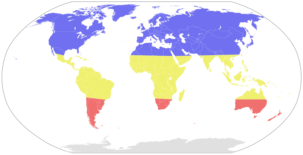
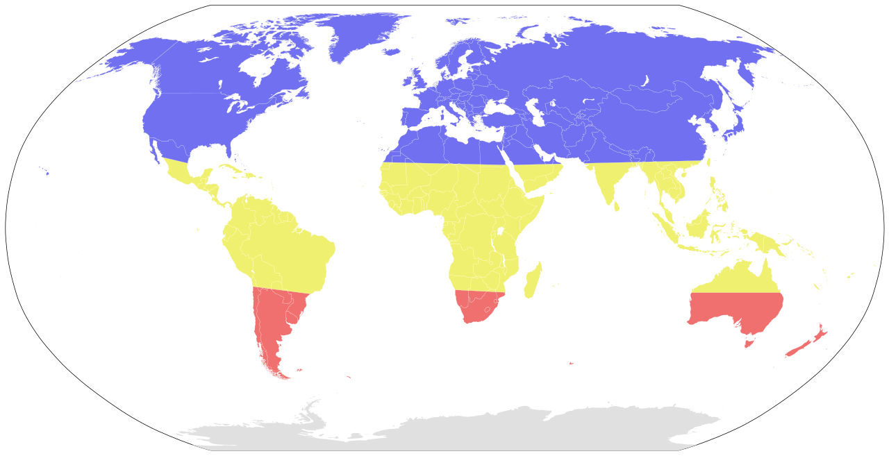
A map showing the seasonal risk areas for influenza, as indicated in the TravelWise™ pamphlet
|
|
| Datum | (UTC) | |
| Vir | ||
| Avtor |
|
Licenca
Datoteka je objavljena pod licenco Creative Commons Priznanje avtorstva-Deljenje pod enakimi pogoji 3.0 Nedoločena.
- Dovoljeno vam je:
- deljenje – reproducirati, distribuirati in javno priobčevati delo
- predelava – predelati delo
- Pod naslednjimi pogoji:
- priznanje avtorstva – Navesti morate ustrezno avtorstvo, povezavo do licence in morebitne spremembe. To lahko storite na kakršen koli primeren način, vendar ne na način, ki bi nakazoval, da dajalec licence podpira vas ali vašo uporabo dela.
- deljenje pod enakimi pogoji – Če boste to vsebino predelali, preoblikovali ali uporabili kot izhodišče za drugo delo, morate svoj prispevek distribuirati pod enako ali združljivo licenco, kot jo ima izvirnik.
Izvorni dnevniški zapis naložitve
This image is a derivative work of the following images:
- File:BlankMap-World6.svg licensed with PD-self
- 2011-08-27T00:51:14Z Anomie 863x443 (1612580 Bytes) South Sudan has been assigned code SS, so use that code.
- 2011-07-30T18:04:36Z Lokal Profil 863x443 (1612578 Bytes) Minor circle related changes and remove the legacy pentagram
- 2011-07-08T23:26:24Z NuclearVacuum 863x443 (1613386 Bytes) South Sudan is free!! Hooray
- 2011-07-04T20:41:30Z NuclearVacuum 863x443 (1615589 Bytes) Restored to previous version, as SS isn't independent yet. But the code is now ready and waiting
- 2011-07-04T20:40:06Z NuclearVacuum 863x443 (1613386 Bytes) Separated South Sudan from (North) Sudan in preparation for SS independence on July 9, 2011.
- 2011-06-27T15:15:14Z Canuckguy 863x443 (1615589 Bytes) restored PR, set id labels for West Bank and Gaza
- 2011-04-01T14:09:57Z NuclearVacuum 863x443 (1614917 Bytes) Mayotte is now a department of France
- 2011-02-17T14:31:36Z NuclearVacuum 863x443 (1614903 Bytes) minor fixes
- 2011-02-13T01:43:20Z Canuckguy 863x443 (1632654 Bytes) minor fix
- 2011-01-22T20:16:24Z NuclearVacuum 863x443 (1614900 Bytes) added lakes
- 2011-01-22T20:12:02Z NuclearVacuum 863x443 (1632622 Bytes) ...
- 2011-01-22T20:08:04Z NuclearVacuum 863x443 (1632651 Bytes) Reverted to version as of 18:31, 17 January 2011
- 2011-01-22T20:07:39Z NuclearVacuum 1173x937 (334238 Bytes) just testing something
- 2011-01-17T18:31:33Z NuclearVacuum 863x443 (1632651 Bytes) minor fix of Sudan
- 2011-01-17T18:26:18Z NuclearVacuum 863x443 (1632651 Bytes) minor fix
- 2011-01-17T18:17:24Z NuclearVacuum 863x443 (1632633 Bytes) clean code
- 2011-01-17T18:12:07Z NuclearVacuum 863x443 (1632625 Bytes) added new class of circles, added Southern Sudan as a region within Sudan.
- 2011-01-15T00:06:15Z NuclearVacuum 863x443 (1631574 Bytes) minor fix
- 2011-01-14T23:51:44Z NuclearVacuum 863x443 (1631571 Bytes) added missing regions of the European Union
- 2011-01-13T14:26:50Z NuclearVacuum 863x443 (1631559 Bytes) minor fix
- 2011-01-13T14:17:57Z NuclearVacuum 863x443 (1631550 Bytes) added the BES Islands to the Netherladns
- 2011-01-07T21:02:08Z NuclearVacuum 863x443 (1631333 Bytes) minor fix
- 2011-01-07T20:55:32Z NuclearVacuum 863x443 (1631333 Bytes) corrected code for the circles
- 2011-01-06T16:44:29Z NuclearVacuum 863x443 (1208206 Bytes) removed all but 5px of whitespace, see talk page
- 2011-01-03T14:03:40Z NuclearVacuum 854x433 (1208195 Bytes) Curaçao and Sint Maarten have been given codes
- 2011-01-02T03:21:03Z Tomchen1989 854x433 (1205379 Bytes) compromised for the bug
- 2010-12-28T01:58:24Z Kintetsubuffalo 853x433 (1205378 Bytes) what are you talking about? nothing is cut off or squished
- 2010-12-28T00:28:42Z NuclearVacuum 940x477 (1631321 Bytes) Reverted to version as of 16:43, 27 October 2010
- 2010-12-19T20:10:58Z Tomchen1989 853x433 (1205378 Bytes) stroke-width of coast
- 2010-12-19T08:51:57Z Tomchen1989 853x433 (1205378 Bytes) minor change
- 2010-12-16T16:14:47Z Tomchen1989 853x433 (1205378 Bytes) radius of the circles changed
- 2010-12-14T22:57:20Z Tomchen1989 853x433 (1208461 Bytes) small fixed
- 2010-12-14T22:36:00Z Tomchen1989 853x433 (1208830 Bytes) had outside whitespace removed; cleaned the code; used tab indent
- 2010-10-27T16:43:23Z NuclearVacuum 940x477 (1631321 Bytes) fixed as part of discussion
- 2010-10-24T03:54:05Z NuclearVacuum 940x477 (1630960 Bytes) I fixed the code so it is valid
- 2010-10-10T22:06:16Z Canuckguy 940x477 (1630991 Bytes) Reverted to version as of 02:01, 18 September 2010 (Neth. Antilles removed, Sint Maarten and Curacao added, Bonaire part of "nl")
- 2010-09-18T02:01:50Z Canuckguy 940x477 (1630802 Bytes) Reverted to version as of 01:03, 9 July 2010. New version to be used October 10, 2010
- 2010-09-18T02:01:03Z Canuckguy 940x477 (1630991 Bytes) version with Sint Maarten and Curacao added, Bonaire as part of Netherlands, and Netherlands Antilles removed. To be used starting October 10, 2010
- 2010-07-09T01:03:28Z NuclearVacuum 940x477 (1630802 Bytes) after thinking about it, I think "aa" is better for the ocean than "zz"
- 2010-07-07T21:49:57Z NuclearVacuum 940x477 (1630805 Bytes) Reverted to version as of 20:25, 7 July 2010
- 2010-07-07T21:49:26Z NuclearVacuum 940x477 (1629207 Bytes) Reverted to version as of 16:45, 25 June 2010
- 2010-07-07T21:48:28Z NuclearVacuum 940x477 (1630623 Bytes) Reverted to version as of 16:51, 29 June 2010 checking
- 2010-07-07T21:47:19Z NuclearVacuum 940x477 (1630506 Bytes) Reverted to version as of 14:49, 1 July 2010 checking something
- 2010-07-07T20:25:43Z NuclearVacuum 940x477 (1630805 Bytes) added marker for Swaziland
- 2010-07-07T19:43:09Z NuclearVacuum 940x477 (1630656 Bytes) added the European Union
- 2010-07-01T14:49:16Z NuclearVacuum 940x477 (1630506 Bytes) minor mistake
- 2010-07-01T14:47:13Z NuclearVacuum 940x477 (1630506 Bytes) Created code for the French Southern and Antarctic Lands.
- 2010-06-29T16:51:08Z NuclearVacuum 940x477 (1630623 Bytes) minor code cleanup
- 2010-06-28T22:28:48Z NuclearVacuum 940x477 (1630576 Bytes) new version taking into account the unrecognized nations and using user-assigned code.
- 2010-06-28T20:16:10Z NuclearVacuum 940x477 (1630640 Bytes) added separate class for unrecognized nations, minor cleanup
Uploaded with derivativeFX
Zgodovina datoteke
Kliknite datum in čas za ogled datoteke, ki je bila takrat naložena.
| Datum in čas | Sličica | Velikost | Uporabnik | Komentar | |
|---|---|---|---|---|---|
| trenutno | 04:57, 10. december 2011 | | 863 × 443 (3,17 MB) | Ninjatacoshell | == {{int:filedesc}} == {{Information |Description=A map showing the seasonal risk areas for influenza, as indicated in [http://www.northeastinfectiousdiseases.org/resources/MapsTearPad.pdf the TravelWise™ pamphlet] <br> Key: <br> <table border="0" cells |
Uporaba datoteke
Datoteka je del naslednje 1 strani slovenske Wikipedije (strani drugih projektov niso navedene):
Globalna uporaba datoteke
To datoteko uporabljajo tudi naslednji vikiji:
- Uporaba na af.wikipedia.org
- Uporaba na ar.wikipedia.org
- Uporaba na da.wikipedia.org
- Uporaba na de.wikipedia.org
- Uporaba na en.wikipedia.org
- Uporaba na hu.wikipedia.org
- Uporaba na hu.wikibooks.org
- Uporaba na ja.wikipedia.org
- Uporaba na kab.wikipedia.org
- Uporaba na ml.wikipedia.org
- Uporaba na or.wikipedia.org
- Uporaba na pt.wikipedia.org
- Uporaba na th.wikipedia.org
- Uporaba na uk.wikipedia.org
- Uporaba na zh.wikipedia.org