Slika:India Malabar Coast locator map.svg

Izvorna datoteka (Datoteka SVG, nominalno 1.639 × 1.852 pikslov, velikost datoteke: 795 KB)
Spodaj prikazane informacije so s tamkajšnje opisne strani.
| Naslov dela |
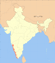
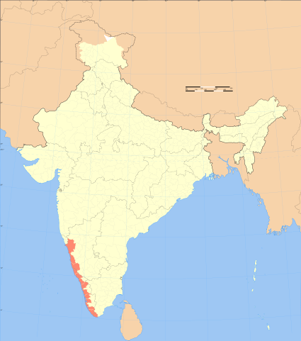
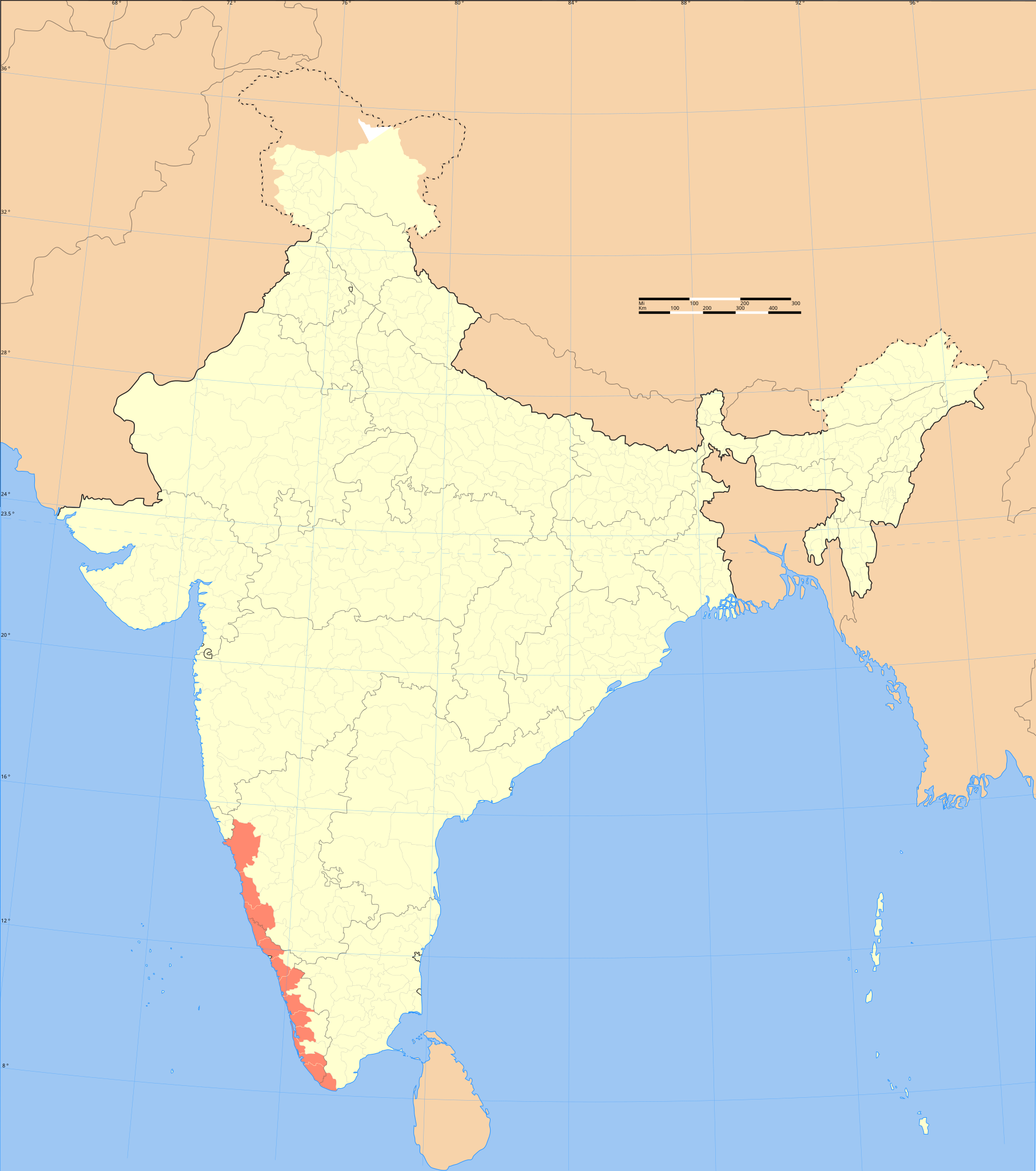
Malabar Coast locator map |
|||||||||
| Opis |
Locator map of the region of Malabar Coast, India with district boundaries. |
|||||||||
| Legenda zemljevida |
 |
|||||||||
| Datum | ||||||||||
| Vir |
lastno delo |
|||||||||
| Ustvarjalec | ||||||||||
| Dovoljenje (Nadaljnja uporaba datoteke) |
Jaz, imetnik avtorskih pravic na tem delu, ga objavljam pod naslednjo licenco: Datoteka je objavljena pod licenco Creative Commons Priznanje avtorstva-Deljenje pod enakimi pogoji 3.0 Nedoločena.
|
|||||||||
| Geotemporalni podatki | ||||||||||
| Datum upodobitve | druga polovica 20. stoletje in 21. stoletje | |||||||||
| Prostorski referenčni sistem | conic | |||||||||
| Omejevalno polje |
|
|||||||||
| Georeferenciranje | Če je neprimerno, nastavite warp_status = skip za skritje. | |||||||||
| Arhivski podatki | ||||||||||
| Opombe | Part of WikiProject India Maps | |||||||||

Notes
Depiction of India's borders
- The territorial boundaries of India are shown as per the actual ground situation in accordance with international practices followed by the United Nations ([1], [2]) and the National Geographic Society ([3], [4])
- This map is meant to be for illustrative purpose only and is not authenticated by official government sources. Please check the list of sources and references used to create the map for a measure of accuracy and verifiability.
- The usage of these maps in India, Pakistan and China are governed by different laws that restrict depictions of boundaries other than what is officially recognized by the state. Please check local laws and modify the map accordingly before use.
Explanation of disputed boundaries


- Boundary of Indian claim : The territory India claims is legally theirs, but the claim is disputed by China and Pakistan.
- Line of Control/Line of Conflict : The de facto administrative boundary recognised by the international community. This UN ceasefire line is considered as a temporary solution to an ongoing conflict since the departure of the British Raj.
Borders of disputed regions
The depicted extent of the former territory of the British Indian Empire, succeeded by Republic of India, may not be accepted by few countries as legal due to ongoing border disputes:
- The northern Himalayan region of the disputed territory Indian-administered Kashmir is claimed by India including (Pakistan-administered Kashmir) and the Chinese-occupied territory of (Ladakh plateau). Since 1972, it is divided between all three countries. See also Line of Control and Line of Actual Control.
- Siachen glacier (shown white) is an actively contested region between India and Pakistan. Since 1984, the region is under Indian control.
- The northeastern territory of Arunachal Pradesh is almost entirely claimed by China as part of its Tibetan territory.
- Minor areas of eastern Kashmir's Ladakh division, Himachal Pradesh and Uttarakhand on the Chinese frontier are claimed by China. These areas are under Indian control.
- A small area of Uttarakhand adjoining the Nepal border along the Sarda river is disputed between the two countries.
For a detailed map of all disputed regions in South Asia, see Image:India disputed areas map.svg
Internal borders
The borders of the state of Meghalaya, Assam and Arunachal Pradesh are shown as interpreted from the North-Eastern Areas (Reorganisation) Act, 1971, but has yet to be verified.
Territorial waters
The limit of the territorial waters of India extends to twelve nautical miles measured from the appropriate baseline. See this for more information.
Zgodovina datoteke
Kliknite datum in čas za ogled datoteke, ki je bila takrat naložena.
| Datum in čas | Sličica | Velikost | Uporabnik | Komentar | |
|---|---|---|---|---|---|
| trenutno | 19:25, 4. september 2006 | | 1.639 × 1.852 (795 KB) | Planemad | {{WikiProject_India_Maps |Title=Malabar Coast locator map |Description=Locator map of the region of Malabar Coast, India with district boundaries. |Source=. |Date=September 2006 |Author=w:user:Planemad |Thumbdir=CHANGE |
Uporaba datoteke
Datoteka je del naslednje 1 strani slovenske Wikipedije (strani drugih projektov niso navedene):
Globalna uporaba datoteke
To datoteko uporabljajo tudi naslednji vikiji:
- Uporaba na ar.wikipedia.org
- Uporaba na bg.wikipedia.org
- Uporaba na bh.wikipedia.org
- Uporaba na bn.wikipedia.org
- Uporaba na en.wikipedia.org
- Uporaba na eo.wikipedia.org
- Uporaba na es.wikipedia.org
- Uporaba na fa.wikipedia.org
- Uporaba na fi.wikipedia.org
- Uporaba na fr.wikipedia.org
- Uporaba na gl.wikipedia.org
- Uporaba na he.wikipedia.org
- Uporaba na hi.wikipedia.org
- Uporaba na hu.wikipedia.org
- Uporaba na id.wikipedia.org
- Uporaba na ja.wikipedia.org
- Uporaba na ka.wikipedia.org
- Uporaba na kn.wikipedia.org
- Uporaba na ko.wikipedia.org
- Uporaba na ml.wikipedia.org
- Uporaba na ms.wikipedia.org
- Uporaba na nn.wikipedia.org
- Uporaba na no.wikipedia.org
- Uporaba na oc.wikipedia.org
- Uporaba na pl.wikipedia.org
- Uporaba na pl.wikivoyage.org
- Uporaba na ru.wikipedia.org
- Uporaba na sh.wikipedia.org
- Uporaba na sv.wikipedia.org
- Uporaba na ta.wikipedia.org
- Uporaba na tl.wikipedia.org
- Uporaba na tt.wikipedia.org
- Uporaba na uk.wikipedia.org
- Uporaba na zh.wikipedia.org