Slika:Iceland Mid-Atlantic Ridge Fig16.gif
Iceland_Mid-Atlantic_Ridge_Fig16.gif (376 × 390 točk, velikost datoteke: 9 KB, MIME-vrsta: image/gif)
Zgodovina datoteke
Kliknite datum in čas za ogled datoteke, ki je bila takrat naložena.
| Datum in čas | Sličica | Velikost | Uporabnik | Komentar | |
|---|---|---|---|---|---|
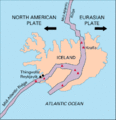
| trenutno | 01:02, 10. marec 2005 |  | 376 × 390 (9 KB) | Svart~commonswiki | Map showing the Mid-Atlantic Ridge splitting Iceland and separating the North American and Eurasian Plates. The map also shows Reykjavik, the capital of Iceland, the Thingvellir area, and the locations of some of Iceland's active volcanoes (red triangles) |
Uporaba datoteke
Datoteka je del naslednje 1 strani slovenske Wikipedije (strani drugih projektov niso navedene):
Globalna uporaba datoteke
To datoteko uporabljajo tudi naslednji vikiji:
- Uporaba na ar.wikipedia.org
- Uporaba na ast.wikipedia.org
- Uporaba na azb.wikipedia.org
- Uporaba na bg.wikipedia.org
- Uporaba na bn.wikipedia.org
- Uporaba na bn.wikivoyage.org
- Uporaba na cs.wikipedia.org
- Uporaba na de.wikipedia.org
- Uporaba na de.wikivoyage.org
- Uporaba na dz.wikipedia.org
- Uporaba na en.wikipedia.org
- Uporaba na eo.wikipedia.org
- Uporaba na es.wikipedia.org
- Uporaba na fiu-vro.wikipedia.org
- Uporaba na fi.wikipedia.org
- Uporaba na hr.wikipedia.org
- Uporaba na hu.wikipedia.org
- Uporaba na is.wikipedia.org
- Uporaba na is.wikibooks.org
- Uporaba na it.wikipedia.org
- Uporaba na ja.wikipedia.org
- Uporaba na ms.wikipedia.org
- Uporaba na nds.wikipedia.org
- Uporaba na nn.wikipedia.org
- Uporaba na no.wikipedia.org
- Uporaba na pl.wikipedia.org
- Uporaba na pt.wikipedia.org
- Uporaba na rm.wikipedia.org
- Uporaba na ro.wikipedia.org
Oglejte si globalno uporabo te datoteke.


