Slika:Iceberg A22A, South Atlantic Ocean.jpg

Velikost tega predogleda: 800 × 530 točk. Druge ločljivosti: 320 × 212 točk | 640 × 424 točk | 1.024 × 678 točk | 1.280 × 848 točk | 2.345 × 1.553 točk.
Izvorna datoteka (2.345 × 1.553 točk, velikost datoteke: 793 KB, MIME-vrsta: image/jpeg)
Spodaj prikazane informacije so s tamkajšnje opisne strani.
Povzetek
| Opis |
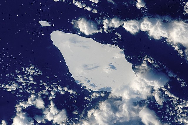
English: This astronaut photograph illustrates the remains of a giant iceberg—designated A22A— that broke off Antarctica in 2002. The iceberg was photographed at a location of 49.9 degrees south latitude, 23.8 degrees west longitude, which is about a third of the distance from South America towards Cape Town, South Africa. A22A is one of the largest icebergs to drift as far north as 50 degrees south latitude, bringing it beneath the daylight path of the International Space Station (ISS). Crew members aboard the ISS were able to locate the ice mass and photograph it, despite the great masses of clouds that often accompany winter storms in the Southern Ocean. The crew’s viewing angle was oblique (not looking straight down) from a point to the west of the berg, and the time of day was early afternoon, as shown by the orientation of the cloud shadows. Dimensions of A22A in early June were 49.9 by 23.4 kilometres, giving it an area of 622 square kilometres, or seven times the area of Manhattan Island.
|
||||||||||||||||||||||||||||||||||||||||||||||||||
| Datum | |||||||||||||||||||||||||||||||||||||||||||||||||||
| Vir | {{URL|example.com|optional display text}} | ||||||||||||||||||||||||||||||||||||||||||||||||||
| Avtor | Image provided by the ISS Crew Earth Observations experiment and the Image Science & Analysis Laboratory, NASA - Johnson Space Center. | ||||||||||||||||||||||||||||||||||||||||||||||||||
| Lokacija objekta | | Ta in druge slike po lokaciji: OpenStreetMap |
|---|
To sliko ali ta video je katalogiziral Johnson Space Center Nacionalne uprave za aeronavtiko in vesolje (NASA) Združenih držav Amerike pod oznako fotografije: ISS015-E-10125. Ta predloga ne označuje avtorskopravnega stanja dela. Ob njej mora stati tudi običajna oznaka avtorskopravnega stanja gradiva. Glejte Commons:Navedba licence. Drugi jeziki:
|
Licenca
| Ta datoteka je v javni domeni, ker jo je izdelala izključno NASA. Avtorskopravna politika NASE pravi, da »Gradivo NASE ni zaščiteno z avtorskimi pravicami, razen če je rečeno drugače.« (glej Template:PD-USGov, stran z avtorskopravno politiko NASE ali Politiko uporabe slik JPL.) | ||
 |
Opozorila:
|
Zgodovina datoteke
Kliknite datum in čas za ogled datoteke, ki je bila takrat naložena.
| Datum in čas | Sličica | Velikost | Uporabnik | Komentar | |
|---|---|---|---|---|---|
| trenutno | 17:25, 22. marec 2013 | | 2.345 × 1.553 (793 KB) | Julian Herzog | Higher resolution and quality |
| 21:54, 5. julij 2009 |  | 1.000 × 1.000 (376 KB) | Originalwana | {{Information |Description={{en|1=This astronaut photograph illustrates the remains of a giant iceberg—designated A22A— that broke off Antarctica in 2002. The iceberg was photographed at a location of 49.9 degrees south latitude, 23.8 degrees west lon |
Uporaba datoteke
Datoteka je del naslednje 1 strani slovenske Wikipedije (strani drugih projektov niso navedene):
Globalna uporaba datoteke
To datoteko uporabljajo tudi naslednji vikiji:
- Uporaba na ar.wikipedia.org
- Uporaba na az.wikipedia.org
- Uporaba na bn.wikipedia.org
- Uporaba na cy.wikipedia.org
- Uporaba na en.wikipedia.org
- Uporaba na eo.wikipedia.org
- Uporaba na it.wikipedia.org
- Uporaba na it.wikibooks.org
- Uporaba na it.wikiversity.org
- Uporaba na la.wikipedia.org
- Uporaba na mk.wikipedia.org
- Uporaba na pt.wikipedia.org
- Uporaba na ta.wikipedia.org
- Uporaba na ta.wiktionary.org
- Uporaba na th.wikipedia.org