Slika:HeimSachsen.png

Velikost tega predogleda: 551 × 599 točk. Druge ločljivosti: 221 × 240 točk | 441 × 480 točk | 881 × 958 točk.
Izvorna datoteka (881 × 958 točk, velikost datoteke: 346 KB, MIME-vrsta: image/png)
Spodaj prikazane informacije so s tamkajšnje opisne strani.

Povzetek
| Opis |
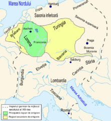
Română: Regiunile de provenienţă ale coloniştilor saşi în Transilvania în secolul al XIII-lea. |
| Datum | |
| Vir | Th.Nagler - Asezarea saşilor în Transilvania - Bucureşti, Editura Kriterion, 1992, planşa X. |
| Avtor | Asybaris |

|
Ta zemljevid je mogoče poustvariti z uporabo vektorske grafike kot SVG-datoteko. To ima več prednosti; več informacij je na razpolago na strani Commons:Media for cleanup. Če je SVG-oblika te datoteke že na razpolago, jo, prosimo, naložite. Potem, ko boste SVG naložili, to predlogo zamenjajte z izrazom {{vector version available|ime nove slike.svg}}.
|
Licenca
| Jaz, imetnik avtorskih pravic na tem delu, izročam to delo v javno domeno. To velja po vsem svetu. V nekaterih državah to pravno morda ni mogoče. Če je tako, Vsakomur dajem (v okviru zakonskih omejitev) brezpogojno pravico, da gradivo uporablja v kateri koli namen. |
Zgodovina datoteke
Kliknite datum in čas za ogled datoteke, ki je bila takrat naložena.
| Datum in čas | Sličica | Velikost | Uporabnik | Komentar | |
|---|---|---|---|---|---|
| trenutno | 20:02, 13. februar 2009 | | 881 × 958 (346 KB) | Asybaris01 | corectii |
| 18:41, 13. februar 2009 |  | 881 × 958 (339 KB) | Asybaris01 | {{Information |Description={{ro|1=Regiunile de provenienţă ale coloniştilor saşi în Transilvania în secolul al XIII-lea.}} |Source=Th.Nagler - Asezarea saşilor în Transilvania - Bucureşti, Editura Kriterion, 1992, planşa X. |Author=[[:ro:Utiliz |
Uporaba datoteke
Datoteka je del naslednje 1 strani slovenske Wikipedije (strani drugih projektov niso navedene):
Globalna uporaba datoteke
To datoteko uporabljajo tudi naslednji vikiji:
- Uporaba na el.wikipedia.org
- Uporaba na en.wikipedia.org
- Uporaba na es.wikipedia.org
- Uporaba na ro.wikipedia.org