Slika:Groundwater zone.png
Višja ločljivost ni na voljo.
Groundwater_zone.png (535 × 303 točk, velikost datoteke: 108 KB, MIME-vrsta: image/png)
Spodaj prikazane informacije so s tamkajšnje opisne strani.
Povzetek
| Opis |
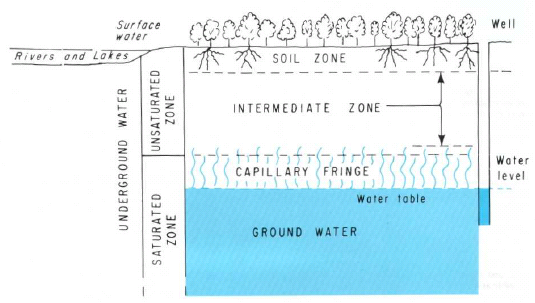
ไทย: น้ำใต้ดินแบ่งออกเป็น 3 โซนได้แก่ soil zone, intermediate zone และ the upper part of capillary fringe |
| Vir | https://pubs.er.usgs.gov/ |
| Avtor | Heath, Ralph C. |
Licenca
This image is in the public domain in the United States because it only contains materials that originally came from the United States Geological Survey, an agency of the United States Department of the Interior. For more information, see the official USGS copyright policy.
|
Zgodovina datoteke
Kliknite datum in čas za ogled datoteke, ki je bila takrat naložena.
| Datum in čas | Sličica | Velikost | Uporabnik | Komentar | |
|---|---|---|---|---|---|
| trenutno | 10:50, 22. februar 2011 | | 535 × 303 (108 KB) | Tanitha | {{Information |Description ={{th|1=น้ำใต้ดินแบ่งออกเป็น 3 โซนได้แก่ soil zone, intermediate zone และ the upper part of capillary fringe}} |Source =http://pubs.er.usgs.gov/ |Author |
Uporaba datoteke
Datoteka je del naslednje 1 strani slovenske Wikipedije (strani drugih projektov niso navedene):
Globalna uporaba datoteke
To datoteko uporabljajo tudi naslednji vikiji:
- Uporaba na hr.wikipedia.org
- Uporaba na th.wikipedia.org