Slika:Grossdeutsches Reich NS Administration 1944.png
Izvorna datoteka (2.615 × 2.030 točk, velikost datoteke: 250 KB, MIME-vrsta: image/png)
Spodaj prikazane informacije so s tamkajšnje opisne strani.
Povzetek
| Opis |
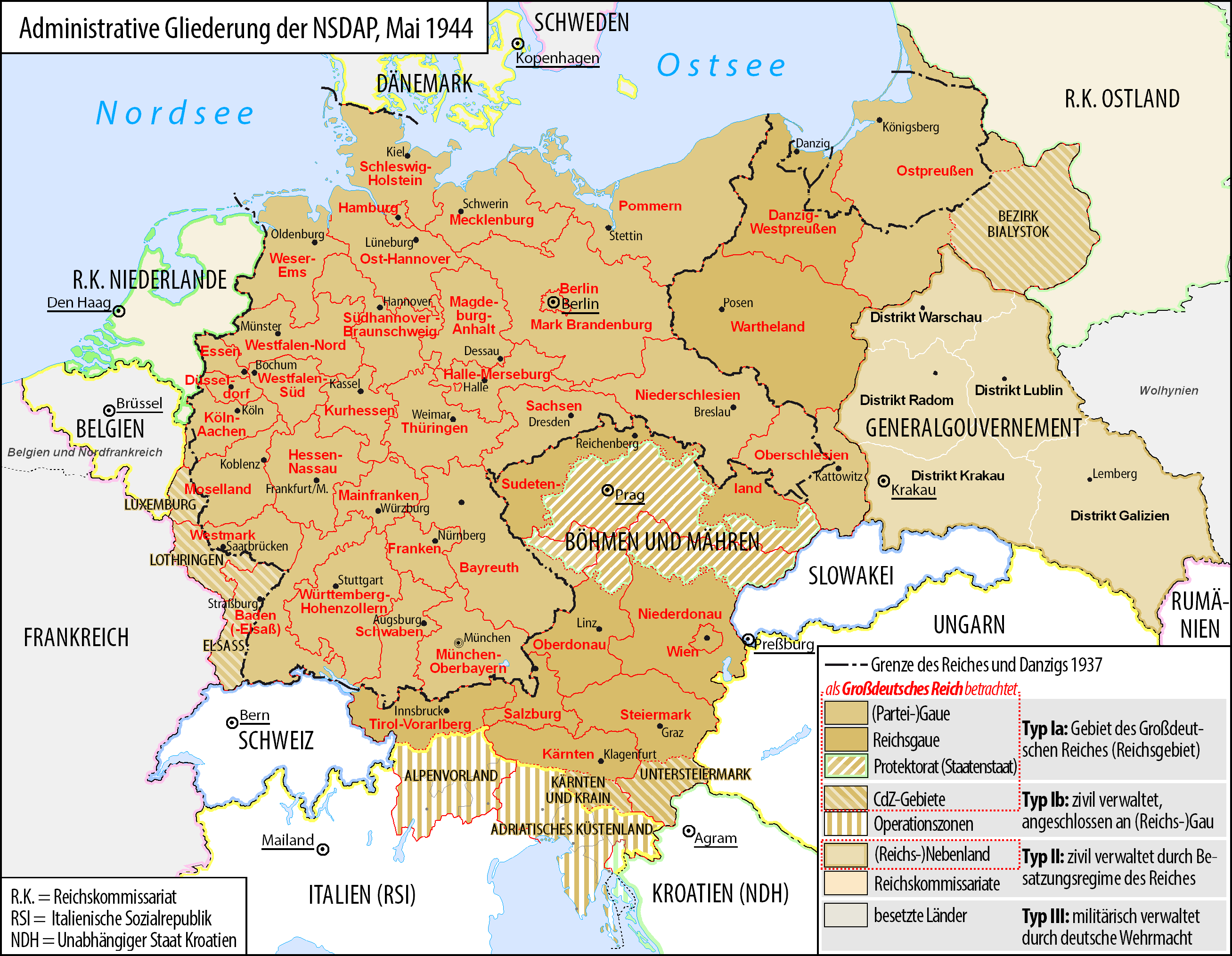
Deutsch: Karte der administrativen Gliederung des Großdeutschen Reiches durch die NSDAP 1944.
English: Map of the administrative division of the Greater German Reich ("Großdeutsches Reich"/"Großdeutschland"/"Greater German Empire"/"Greater Germany") by the NSDAP 1944 (in German).
Polski: Mapa Wielkiej Rzeszy Niemieckiej (1944) |
||
| Datum | |||
| Vir | lastno delo | ||
| Avtor | Bennet Schulte | ||
| Dovoljenje (Nadaljnja uporaba datoteke) |
|
||
| Druge različice |
|


Licenca
- Dovoljeno vam je:
- deljenje – reproducirati, distribuirati in javno priobčevati delo
- predelava – predelati delo
- Pod naslednjimi pogoji:
- priznanje avtorstva – Navesti morate ustrezno avtorstvo, povezavo do licence in morebitne spremembe. To lahko storite na kakršen koli primeren način, vendar ne na način, ki bi nakazoval, da dajalec licence podpira vas ali vašo uporabo dela.
- deljenje pod enakimi pogoji – Če boste to vsebino predelali, preoblikovali ali uporabili kot izhodišče za drugo delo, morate svoj prispevek distribuirati pod enako ali združljivo licenco, kot jo ima izvirnik.

|
Ta dokument je dovoljeno kopirati, razširjati in/ali spreminjati pod pogoji Licence GNU za prosto dokumentacijo, različica 1.2 ali katera koli poznejša, ki jo je objavila ustanova Free Software Foundation; brez nespremenljivih delov ter brez besedil na sprednji ali zadnji platnici. Kopija licence je vključena v razdelek Licenca GNU za prosto dokumentacijo. |
Zgodovina datoteke
Kliknite datum in čas za ogled datoteke, ki je bila takrat naložena.
| Datum in čas | Sličica | Velikost | Uporabnik | Komentar | |
|---|---|---|---|---|---|
| trenutno | 07:23, 3. junij 2017 | | 2.615 × 2.030 (250 KB) | Exec | auf vielfachen Wunsch wurden die zum Zeitpunkt der Darstellung existierenden militärisch verwalteten Gebiete "Wolhynien" (Rest von RK Ukraine) sowie "Belgien und Nordfrankreich" beschriftet und abgegrenzt wenn abweichend von Staatsgrenzen |
| 02:26, 4. februar 2016 |  | 2.615 × 2.030 (344 KB) | Exec | Reverted to version as of 10:37, 11 September 2015 (UTC): thematic content don't include military administative units, see https://commons.wikimedia.org/wiki/File_talk:Greater_German_Reich_NS_Administration_1944.png#Problems_with_the_map | |
| 17:04, 6. december 2015 |  | 2.607 × 2.022 (579 KB) | Braganza | Reverted to version as of 22:32, 7 July 2014 (UTC) | |
| 12:37, 11. september 2015 |  | 2.615 × 2.030 (344 KB) | RokerHRO | optipng -i0 -zc1-9 -zm1-9 -zs0-3 -f0-5 -i0 → 35.13% decrease | |
| 11:32, 27. junij 2015 |  | 2.615 × 2.030 (530 KB) | Exec | - clearified phrase for dotted line (statt "dargestellt als", "als betrachtet" | |
| 11:23, 27. junij 2015 |  | 2.616 × 2.029 (530 KB) | Exec | - added subdevision of the Operationszonen - fixed explanation of red dotted line (visualisation in cartographic materials as Großdeutsches Reich) and exclude Operationszonen | |
| 02:18, 3. april 2015 |  | 2.607 × 2.022 (231 KB) | Exec | Reverted to version as of 21:17, 17 July 2014 because no fixes are identified but some black objects are switched to grey with out logic and benefit.undaries to grey | |
| 09:08, 29. marec 2015 |  | 2.607 × 2.022 (345 KB) | DIREKTOR | Small fix. | |
| 23:17, 17. julij 2014 |  | 2.607 × 2.022 (231 KB) | Execger | Boundaries of millitary administration is not part of the thematic content. | |
| 00:32, 8. julij 2014 |  | 2.607 × 2.022 (579 KB) | Victor falk~commonswiki | belgien und nordfrankreich |
Uporaba datoteke
Datoteka je del naslednje 1 strani slovenske Wikipedije (strani drugih projektov niso navedene):
Globalna uporaba datoteke
To datoteko uporabljajo tudi naslednji vikiji:
- Uporaba na cs.wikipedia.org
- Uporaba na da.wikipedia.org
- Uporaba na de.wikipedia.org
- Gau
- Geschichte Österreichs
- Generalgouvernement
- Beneš-Dekrete
- Reichsstatthalter
- Reichsgau
- Danzig-Westpreußen
- Deutsche Frage
- Geschichte der Steiermark
- Kriegsschauplatz Mittelmeerraum
- NS-Staat
- Diskussion:Liste der größten deutschen Städte
- Liste der Wappen in Deutschland
- Geschichte Niederösterreichs
- Deutschland
- Operationszone Adriatisches Küstenland
- Diskussion:Deutschland/Archiv/2
- Geschichte Oberösterreichs
- Ostmarkgesetz
- Portal Diskussion:Nationalsozialismus/Archiv/2010
- Liste der Postleitregionen in Deutschland
- Wikipedia:Kartenwerkstatt/Archiv/Zurückgewiesene und zurückgestellte Aufträge 2012
- Portal Diskussion:Nationalsozialismus/Archiv/2014
- Diskussion:Uschi Nerke
- Wikipedia:Redaktion Geschichte/Archiv/2023/Feb
- Uporaba na frr.wikipedia.org
- Uporaba na fr.wikipedia.org
- Uporaba na fr.wiktionary.org
- Uporaba na gl.wikipedia.org
- Uporaba na hak.wikipedia.org
- Uporaba na he.wikipedia.org
- Uporaba na it.wikipedia.org
- Uporaba na ja.wikipedia.org
- Uporaba na lb.wikipedia.org
Oglejte si globalno uporabo te datoteke.