Slika:G-F triangulation.jpg
Višja ločljivost ni na voljo.
G-F_triangulation.jpg (272 × 400 točk, velikost datoteke: 21 KB, MIME-vrsta: image/jpeg)
Spodaj prikazane informacije so s tamkajšnje opisne strani.
Povzetek
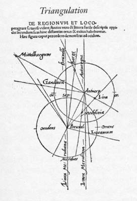
| Opis | Gemma Frisius's 1533 diagram introducing the idea of triangulation into the science of surveying. Having established a baseline, eg the cities of Brussels and Antwerp, the location of other cities, eg Middelburg, can be found by taking its compass direction at each end of the baseline, and plotting where the two directions cross. Note that this was only a theoretical presentation of the concept -- because of hills etc, it is in fact actually impossible to see Middelburg from either Brussels or Antwerp! Nevertheless, the figure soon became well known all across Europe. |
| Datum | |
| Vir | Libellus de locorum describendorum ratione. This scan found at [1] |
| Avtor | Gemma Frisius |
![[1]](http://www.math.yorku.ca/SCS/Gallery/images/G-F_triangulation.jpg)
Licenca
|
To delo je v javni domeni tudi v državah in na območjih, kjer trajajo avtorske pravice za časa avtorjevega življenja in še 100 let ali manj po tem. | |
| Datoteka je bila prepoznana kot prosta omejitev po avtorskem pravu, vključno z vsemi povezanimi in sorodnimi pravicami. | |
Zgodovina datoteke
Kliknite datum in čas za ogled datoteke, ki je bila takrat naložena.
| Datum in čas | Sličica | Velikost | Uporabnik | Komentar | |
|---|---|---|---|---|---|
| trenutno | 18:46, 30. april 2008 | | 272 × 400 (21 KB) | Jheald | {{Information |Description=en:Gemma Frisius's 1533 diagram introducing the idea of en:triangulation into the science of surveying. Having established a baseline, eg the cities of Brussels and Antwerp, the location of other cities, eg Middelberg |
Uporaba datoteke
Datoteka je del naslednje 1 strani slovenske Wikipedije (strani drugih projektov niso navedene):
Globalna uporaba datoteke
To datoteko uporabljajo tudi naslednji vikiji:
- Uporaba na de.wikipedia.org
- Uporaba na de.wiktionary.org
- Uporaba na en.wikipedia.org
- Uporaba na eo.wikipedia.org
- Uporaba na ja.wikipedia.org
- Uporaba na pl.wikipedia.org
- Uporaba na pl.wiktionary.org
- Uporaba na ru.wikipedia.org
- Uporaba na zh.wikipedia.org