Slika:Fladen Light.PNG
Višja ločljivost ni na voljo.
Fladen_Light.PNG (270 × 312 točk, velikost datoteke: 112 KB, MIME-vrsta: image/png)
Spodaj prikazane informacije so s tamkajšnje opisne strani.
Povzetek
| Opis |
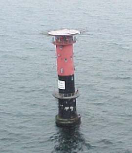
English: Fladen light, (57°13'N., 11°50'E.), equipped with a racon, is shown from a prominent floodlit tower, 26m high, standing on the NE side of Fladen, a sand bank with a least depth of 5.9 meters in teh Kattegat |
| Datum | |
| Vir | http://www.nga.mil/portal/site/maritime/?epi_menuItemID=eb128c56b8e903e25b2a7fbd3227a759&epi_menuID=35ad5b8aabcefa1a0fc133443927a759&epi_baseMenuID=e106a3b5e50edce1fec24fd73927a759 Sailing Directions Enroute, Vol. 193, page 95 |
| Avtor | NGA |
Licenca
This image is a work of the United States National Geospatial-Intelligence Agency or one of its predecessor agencies. As a work of the U.S. federal government, the image is in the public domain.
|
 |
Zgodovina datoteke
Kliknite datum in čas za ogled datoteke, ki je bila takrat naložena.
| Datum in čas | Sličica | Velikost | Uporabnik | Komentar | |
|---|---|---|---|---|---|
| trenutno | 08:27, 13. avgust 2009 | | 270 × 312 (112 KB) | Ratzer | {{Information |Description={{en|1=Fladen light, (57°13'N., 11°50'E.), equipped with a racon, is shown from a prominent floodlit tower, 26m high, standing on the NE side of Fladen, a sand bank with a least depth of 5.9 meters in teh Kattegat}} |Source=ht |
Uporaba datoteke
Datoteka je del naslednje 1 strani slovenske Wikipedije (strani drugih projektov niso navedene):
Globalna uporaba datoteke
To datoteko uporabljajo tudi naslednji vikiji:
- Uporaba na ar.wikipedia.org
- Uporaba na bn.wikipedia.org
- Uporaba na ca.wikipedia.org
- Uporaba na de.wikipedia.org
- Uporaba na en.wikipedia.org
- Uporaba na hr.wikipedia.org
- Uporaba na la.wikipedia.org
- Uporaba na sv.wikipedia.org
- Uporaba na www.wikidata.org