Slika:Arabian Desert.jpg
Arabian_Desert.jpg (500 × 428 točk, velikost datoteke: 116 KB, MIME-vrsta: image/jpeg)
Spodaj prikazane informacije so s tamkajšnje opisne strani.
Povzetek
| Opis |
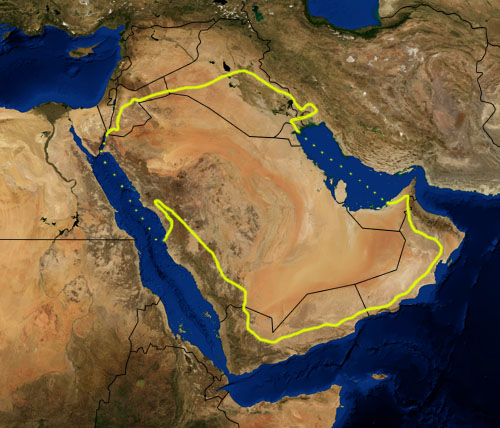
This is a map showing the location of the Arabian Desert. The yellow line encloses ecoregions as delineated by the World Wide Fund for Nature: the "Arabian Desert and East Sahero-Arabian xeric shrublands", and the "Arabian Gulf desert and semi-desert" (a narrow strip along the Persian Gulf coast), and the "Red Sea Nubo-Sindian tropical desert and semi-desert" (along the Red Sea and in patches throughout the Arabian peninsula). National boundaries are shown in black. I, Pfly, made it using NASA Blue Marble imagery and ecoregion GIS data which I simplified and digitized in Photoshop. WWF code PA1303 |
| Datum | |
| Vir | NASA, plus my additions by myself. |
| Avtor | Pfly |
Licenca
| Ta datoteka je v javni domeni, ker jo je izdelala izključno NASA. Avtorskopravna politika NASE pravi, da »Gradivo NASE ni zaščiteno z avtorskimi pravicami, razen če je rečeno drugače.« (glej Template:PD-USGov, stran z avtorskopravno politiko NASE ali Politiko uporabe slik JPL.) | ||
 |
Opozorila:
|
Zgodovina datoteke
Kliknite datum in čas za ogled datoteke, ki je bila takrat naložena.
| Datum in čas | Sličica | Velikost | Uporabnik | Komentar | |
|---|---|---|---|---|---|
| trenutno | 23:39, 22. januar 2007 | | 500 × 428 (116 KB) | Pfly | {{Information |Description=This is a map showing the location of the Desert. The yellow line encloses ecoregions as delineated by the World Wide Fund for Nature: the "Arabian Desert and East Sahero |
Uporaba datoteke
Datoteka je del naslednje 1 strani slovenske Wikipedije (strani drugih projektov niso navedene):
Globalna uporaba datoteke
To datoteko uporabljajo tudi naslednji vikiji:
- Uporaba na an.wikipedia.org
- Uporaba na ar.wikipedia.org
- Uporaba na arz.wikipedia.org
- Uporaba na ast.wikipedia.org
- Uporaba na azb.wikipedia.org
- Uporaba na az.wikipedia.org
- Uporaba na ba.wikipedia.org
- Uporaba na bg.wikipedia.org
- Uporaba na bn.wikipedia.org
- Uporaba na bs.wikipedia.org
- Uporaba na ca.wikipedia.org
- Uporaba na ckb.wikipedia.org
- Uporaba na cs.wikipedia.org
- Uporaba na da.wikipedia.org
- Uporaba na el.wikipedia.org
- Uporaba na eo.wikipedia.org
- Uporaba na es.wikipedia.org
- Uporaba na eu.wikipedia.org
- Uporaba na fa.wikipedia.org
- Uporaba na fi.wikipedia.org
- Uporaba na fr.wikipedia.org
- Uporaba na gd.wikipedia.org
- Uporaba na gl.wikipedia.org
- Uporaba na he.wikipedia.org
- Uporaba na hy.wikipedia.org
- Uporaba na it.wikipedia.org
- Uporaba na ja.wikipedia.org
- Uporaba na ka.wikipedia.org
- Uporaba na kn.wikipedia.org
- Uporaba na ko.wikipedia.org
- Uporaba na ky.wikipedia.org
- Uporaba na lt.wikipedia.org
- Uporaba na mai.wikipedia.org
- Uporaba na ml.wikipedia.org
- Uporaba na ne.wikipedia.org
- Uporaba na nl.wikipedia.org
- Uporaba na nn.wikipedia.org
- Uporaba na no.wikipedia.org
- Uporaba na oc.wikipedia.org
- Uporaba na pa.wikipedia.org
- Uporaba na pnb.wikipedia.org
- Uporaba na pt.wikipedia.org
Oglejte si globalno uporabo te datoteke.