Slika:Special member state territories and the European Union.svg

Velikost tega predogleda PNG datoteke SVG: 512 × 258 točk. Druge ločljivosti: 320 × 161 točk | 640 × 323 točk | 1.024 × 516 točk | 1.280 × 645 točk | 2.560 × 1.290 točk.
Izvorna datoteka (Datoteka SVG, nominalno 512 × 258 pikslov, velikost datoteke: 835 KB)
Spodaj prikazane informacije so s tamkajšnje opisne strani.
Povzetek
| Opis |
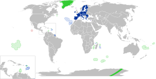
English:
European Union
Outermost regions
Overseas countries and territories
Special cases
Other special territories Français : Union européenne
Régions ultrapériphériques
Pays et territoires d'outre-mer
Cas spéciaux
Autres territoires spéciaux |
| Datum | |
| Vir | lastno delo |
| Avtor | Glentamara |
| SVG razvoj | Ta vektorska slika je bila ustvarjena z Inkscape, or with something else. |
Licenca
| Jaz, imetnik avtorskih pravic na tem delu, izročam to delo v javno domeno. To velja po vsem svetu. V nekaterih državah to pravno morda ni mogoče. Če je tako, Vsakomur dajem (v okviru zakonskih omejitev) brezpogojno pravico, da gradivo uporablja v kateri koli namen. |
Zgodovina datoteke
Kliknite datum in čas za ogled datoteke, ki je bila takrat naložena.
| Datum in čas | Sličica | Velikost | Uporabnik | Komentar | |
|---|---|---|---|---|---|
| trenutno | 21:12, 8. junij 2022 | | 512 × 258 (835 KB) | Nablicus | new version |
| 12:13, 17. julij 2020 |  | 512 × 259 (736 KB) | Alcaios | fixed – those were models I use to check the scale | |
| 01:03, 17. julij 2020 |  | 512 × 258 (672 KB) | Nablicus | Reverted to version as of 19:08, 16 July 2020 (UTC). There is an extra UK and Iceland in the middle of Canada... | |
| 21:53, 16. julij 2020 |  | 512 × 259 (753 KB) | Alcaios | frame | |
| 21:50, 16. julij 2020 |  | 512 × 258 (681 KB) | Alcaios | minor fixed on Greenland mar. zone | |
| 21:46, 16. julij 2020 |  | 512 × 258 (681 KB) | Alcaios | Added maritime zone of Gree,land based on https://www.marineregions.org/eezdetails.php?mrgid=8438 | |
| 21:32, 16. julij 2020 |  | 512 × 259 (752 KB) | Alcaios | added Faroe Islands' maritime zone | |
| 21:08, 16. julij 2020 |  | 512 × 258 (672 KB) | Alcaios | Maritime zones in the eastern Caribbean at the right scale, with the help of https://commons.wikimedia.org/wiki/File:Caribbean_maritime_boundaries_map.svg | |
| 20:44, 16. julij 2020 |  | 512 × 259 (742 KB) | Alcaios | slight realignments | |
| 20:38, 16. julij 2020 |  | 512 × 259 (742 KB) | Alcaios | typo in previous edit, read: "Northern Cyprus is not a special member state territory since..." –– the Åland archipelago is larger and almost reaches the Finnish coast |
Uporaba datoteke
Datoteka je del naslednje 1 strani slovenske Wikipedije (strani drugih projektov niso navedene):
Globalna uporaba datoteke
To datoteko uporabljajo tudi naslednji vikiji:
- Uporaba na ar.wikipedia.org
- Uporaba na br.wikipedia.org
- Uporaba na cs.wikipedia.org
- Uporaba na de.wikipedia.org
- Uporaba na en.wikipedia.org
- European Union
- Neocolonialism
- Outline of the European Union
- Special territories of members of the European Economic Area
- Potential enlargement of the European Union
- External border of the European Union
- User:Falcaorib
- User:Xicomaia/sandbox
- User:Spinykitsune65/sandbox2
- User:A diehard editor/sandbox/EU infobox
- Uporaba na fa.wikipedia.org
- Uporaba na fr.wikipedia.org
- Aruba
- Ceuta
- Polynésie française
- Groenland
- Açores
- Saint-Pierre-et-Miquelon
- Îles Canaries
- Madère
- Îles Kerguelen
- Île Clipperton
- Îles Féroé
- Région ultrapériphérique
- Îles Éparses de l'océan Indien
- Curaçao
- Åland
- Melilla
- Archipel Crozet
- Terre Adélie
- Bonaire
- Saba
- Saint-Eustache (Antilles)
- Peñón de Vélez de la Gomera
- Peñón de Alhucemas
- Îles Saint-Paul et Amsterdam
- Plazas de soberanía
- Nouvelle-Calédonie
- Saint-Martin (royaume des Pays-Bas)
- Saint-Martin (Antilles françaises)
- Pays et territoire d'outre-mer
- Saint-Barthélemy (Antilles françaises)
- Union européenne
- États membres de l'Union européenne
- Terres australes et antarctiques françaises
Oglejte si globalno uporabo te datoteke.