Slika:High Asia Mountain Ranges.jpg

Velikost tega predogleda: 763 × 600 točk. Druge ločljivosti: 306 × 240 točk | 611 × 480 točk | 978 × 768 točk | 1.280 × 1.006 točk | 2.560 × 2.011 točk | 5.600 × 4.400 točk.
Izvorna datoteka (5.600 × 4.400 točk, velikost datoteke: 10,79 MB, MIME-vrsta: image/jpeg)
Spodaj prikazane informacije so s tamkajšnje opisne strani.
Povzetek
| Opis |
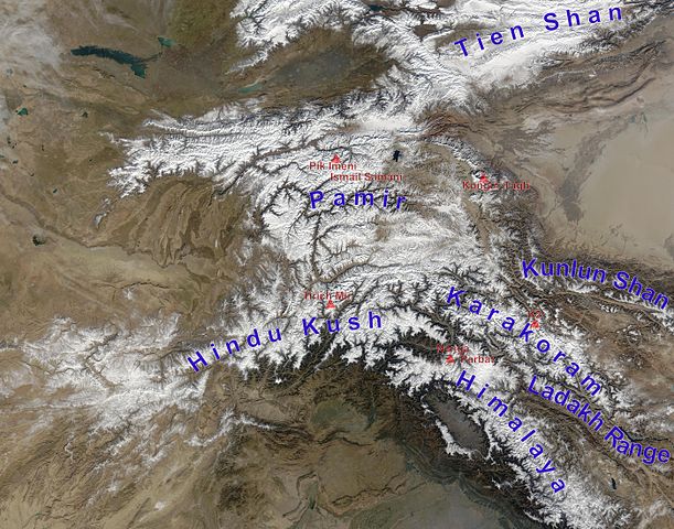
English: high Asian mountain ranges and their highest mountains:
Deutsch: Die innerasiatischen Hochgebirge:
|
| Datum | (UTC) |
| Vir |
Ta datoteka je izpeljana iz: Hindu Kush satellite image.jpg: |
| Avtor |
|
| Ta slika je digitalno obdelana. Opravljene so bile naslednje spremembe: mountain ranges (and highest mountains) labelled. Izvirnik je na voljo tukaj: Hindu Kush satellite image.jpg. Spremembe je opravil uporabnik Rupert Pupkin.
|
Licenca
| Ta datoteka je v javni domeni, ker jo je izdelala izključno NASA. Avtorskopravna politika NASE pravi, da »Gradivo NASE ni zaščiteno z avtorskimi pravicami, razen če je rečeno drugače.« (glej Template:PD-USGov, stran z avtorskopravno politiko NASE ali Politiko uporabe slik JPL.) | ||
 |
Opozorila:
|
Izvorni dnevniški zapis naložitve
This image is a derivative work of the following images:
- File:Hindu_Kush_satellite_image.jpg licensed with PD-USGov-NASA
- 2006-06-06T04:39:19Z Avenue 5600x4400 (5255682 Bytes) {{Information |Description=The Hindu Kush occupies the lower-left-center of this true-color MODIS satellite image, acquired 28 November 2003. |Source=[NASA's Earth Observatory http://earthobservatory.nasa.gov/Newsroom/NewImag
Uploaded with derivativeFX
Zgodovina datoteke
Kliknite datum in čas za ogled datoteke, ki je bila takrat naložena.
| Datum in čas | Sličica | Velikost | Uporabnik | Komentar | |
|---|---|---|---|---|---|
| trenutno | 15:05, 27. november 2012 | | 5.600 × 4.400 (10,79 MB) | Rupert Pupkin | ladakh range added |
| 13:15, 27. november 2012 |  | 5.600 × 4.400 (10,71 MB) | Rupert Pupkin | == {{int:filedesc}} == {{Information |Description=The Hindu Kush occupies the lower-left-center of this true-color MODIS satellite image, acquired 28 November 2003. |Source={{Derived from|Hindu_Kush_satellite_image.jpg|display=50}} |Date=2012-11-27 11:... |
Uporaba datoteke
Datoteka je del naslednjih 2 strani slovenske Wikipedije (strani drugih projektov niso navedene):
Globalna uporaba datoteke
To datoteko uporabljajo tudi naslednji vikiji:
- Uporaba na af.wikipedia.org
- Uporaba na ba.wikipedia.org
- Uporaba na bcl.wikipedia.org
- Uporaba na bn.wikipedia.org
- Uporaba na ceb.wikipedia.org
- Uporaba na de.wikipedia.org
- Uporaba na en.wikipedia.org
- Uporaba na en.wikivoyage.org
- Uporaba na es.wikipedia.org
- Uporaba na eu.wikipedia.org
- Uporaba na fa.wikipedia.org
- Uporaba na fa.wikivoyage.org
- Uporaba na fr.wikipedia.org
- Uporaba na hy.wikipedia.org
- Uporaba na id.wikipedia.org
- Uporaba na it.wikipedia.org
- Uporaba na lt.wikipedia.org
- Uporaba na ms.wikipedia.org
- Uporaba na nl.wikipedia.org
- Uporaba na pl.wikipedia.org
- Uporaba na pnb.wikipedia.org
- Uporaba na ps.wikipedia.org
- Uporaba na pt.wikipedia.org
- Uporaba na ru.wikipedia.org
- Uporaba na sco.wikipedia.org
- Uporaba na sd.wikipedia.org
- Uporaba na simple.wikipedia.org
- Uporaba na sv.wikipedia.org
- Uporaba na ta.wikipedia.org
Oglejte si globalno uporabo te datoteke.