Slika:Aeolian Islands.jpg

Velikost tega predogleda: 396 × 599 točk. Druge ločljivosti: 159 × 240 točk | 317 × 480 točk | 508 × 768 točk | 677 × 1.024 točk | 2.032 × 3.072 točk.
Izvorna datoteka (2.032 × 3.072 točk, velikost datoteke: 610 KB, MIME-vrsta: image/jpeg)
Spodaj prikazane informacije so s tamkajšnje opisne strani.
Povzetek
| Opis |
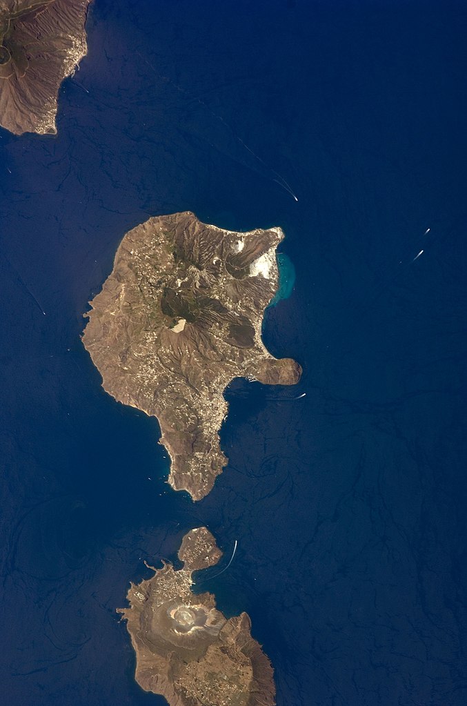
English: This detailed astronaut photograph features Lipari Island and the northern portion of Vulcano Island. Tan, speckled areas on both islands are urban areas and towns. Lipari is the largest of the Aeolian Islands, and it is a popular tourist destination due to its rugged volcanic topography and beaches (several boat wakes are visible around the islands). White pumice beaches and caves are located along the northern and northeastern coastlines of Lipari; black sand beaches derived from lava flows can also be found on the island. The most recent eruptive activity on Lipari took place from approximately AD 580–729.
|
||||||||||||||||||||||||||||||||||||||||||||||||||
| Datum | |||||||||||||||||||||||||||||||||||||||||||||||||||
| Vir | NASA Earth Observatory | ||||||||||||||||||||||||||||||||||||||||||||||||||
| Avtor | This image was taken by the NASA Expedition 17 crew. | ||||||||||||||||||||||||||||||||||||||||||||||||||
| Lokacija fotoaparata | | Ta in druge slike po lokaciji: OpenStreetMap |
|---|
To sliko ali ta video je katalogiziral Johnson Space Center Nacionalne uprave za aeronavtiko in vesolje (NASA) Združenih držav Amerike pod oznako fotografije: ISS017-E-9777. Ta predloga ne označuje avtorskopravnega stanja dela. Ob njej mora stati tudi običajna oznaka avtorskopravnega stanja gradiva. Glejte Commons:Navedba licence. Drugi jeziki:
|
This photograph was acquired with a Nikon D2Xs digital camera fitted with a 400 mm lens, and is provided by the ISS Crew Earth Observations experiment and the Image Science & Analysis Laboratory, Johnson Space Center.
Licenca
| Ta datoteka je v javni domeni, ker jo je izdelala izključno NASA. Avtorskopravna politika NASE pravi, da »Gradivo NASE ni zaščiteno z avtorskimi pravicami, razen če je rečeno drugače.« (glej Template:PD-USGov, stran z avtorskopravno politiko NASE ali Politiko uporabe slik JPL.) | ||
 |
Opozorila:
|
Zgodovina datoteke
Kliknite datum in čas za ogled datoteke, ki je bila takrat naložena.
| Datum in čas | Sličica | Velikost | Uporabnik | Komentar | |
|---|---|---|---|---|---|
| trenutno | 03:45, 15. november 2013 | | 2.032 × 3.072 (610 KB) | Rotatebot | Bot: Image rotated by 90° |
| 19:07, 4. maj 2011 |  | 3.072 × 2.039 (555 KB) | Originalwana | higher res | |
| 18:23, 23. maj 2009 |  | 939 × 586 (115 KB) | Originalwana | {{Information |Description={{en|1=This detailed astronaut photograph features Lipari Island and the northern portion of Vulcano Island. Tan, speckled areas on both islands are urban areas and towns. Lipari is the largest of the Aeolian Islands, and it is |
Uporaba datoteke
Datoteka je del naslednje 1 strani slovenske Wikipedije (strani drugih projektov niso navedene):
Globalna uporaba datoteke
To datoteko uporabljajo tudi naslednji vikiji:
- Uporaba na ar.wikipedia.org
- Uporaba na ast.wikipedia.org
- Uporaba na ca.wikipedia.org
- Uporaba na ceb.wikipedia.org
- Uporaba na cy.wikipedia.org
- Uporaba na de.wikivoyage.org
- Uporaba na el.wikipedia.org
- Uporaba na en.wikipedia.org
- Uporaba na en.wikivoyage.org
- Uporaba na es.wikipedia.org
- Uporaba na eu.wikipedia.org
- Uporaba na fr.wikivoyage.org
- Uporaba na gl.wikipedia.org
- Uporaba na he.wikivoyage.org
- Uporaba na hr.wikipedia.org
- Uporaba na id.wikipedia.org
- Uporaba na it.wikipedia.org
- Uporaba na it.wikivoyage.org
- Uporaba na ko.wikipedia.org
- Uporaba na lb.wikipedia.org
- Uporaba na nl.wikipedia.org
- Uporaba na ro.wikipedia.org
- Uporaba na www.wikidata.org
- Uporaba na zh-yue.wikipedia.org
- Uporaba na zh.wikipedia.org