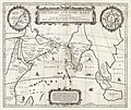
Slika:1658 Jansson Map of the Indian Ocean (Erythrean Sea) in Antiquity - Geographicus - ErythraeanSea-jansson-1658.jpg

Izvorna datoteka(5.000 × 4.194 točk, velikost datoteke: 6,03 MB, MIME-vrsta: image/jpeg)


Jan Janssonius: Erythraei Sive Rubri Maris Periplus.   (Wikidata search (Cirrus search) Wikidata query (SPARQL)  Create new Wikidata item based on this file)
Umetnik/izdelovalec
Jan Janssonius  (1588–1664)  wikidata:Q949492 s:it:Autore:Johannes Janssonius
 
Nadomestna imena
Jan Jansson, Jan Jansz, Jan Janszoon, Joannes Janssonius
Opis nizozemski kartograf, založnik in prodajalec natisov
Datum rojstva/smrti 1588 Uredite to v Wikipodatkih 11. julija 1664 / 1664 Uredite to v Wikipodatkih
Kraj rojstva/smrti Arnhem Amsterdam
Obdobje ustvarjanja od 1616 do 1664
date QS:P,+1650-00-00T00:00:00Z/7,P580,+1616-00-00T00:00:00Z/9,P582,+1664-00-00T00:00:00Z/9
Kraj ustvarjanja
Amsterdam (1612–1664); Arnhem (1612–1612) Uredite to v Wikipodatkih
Normativna kontrola
artist QS:P170,Q949492
Naslov
Erythraei Sive Rubri Maris Periplus.
Opis
English: An unusual and attractive 1658 map of the Indian Ocean, or Erythraean Sea, as it was in antiquity. Composed by Jan Jansson after a similar 1597 map published by A. Ortelius in his Parergon . Covers from Egypt and the Nile valley eastward past Arabia and India, to Southeast Asia and Java. Cartographically, India, Arabia, and Africa roughly correspond to the conventions of the period. Southeast Asia is less recognizable, but the Malay Peninsula, Sumatra, and Java are clearly noted. Most of the place names used throughout are derived from Ptolemy, who himself based his description of the region heavily on records from Alexander the Great's conquests. Two smaller maps in the upper left and right quadrants are of exceptional interest. The upper left chart shows northwestern Africa and is titled Annonis Periplus. This is a reference to the legendary expeditions of the Carthaginian King Hanno, said to have been the first to access the Indian Ocean by sailing around the southern tip of Africa. Incidentally, en route, he is also said to have been the first to tame a lion. The upper right chart shows the northern polar regions as they were perceived at the time. A landmass covering the polar ice cap is indentified as Hyperborea. To the left of this, roughly where North America rests today, the island of Atlantis appears; while Scythia, Europe (Thule) and Asia are on the right. Greenland and possibly Iceland appear at the bottom. This map is intended to point out the possibility of a Northeast Passage to Asia, which was at the time being actively sought after by Dutch, English, and Russian navigators. Both smaller maps, the primary title area at top center, and an Latin explanation for the map at bottom center, are surrounded by baroque strapwork style borders. This remarkable map was published in volume six, the Orbis Antiquus , of Jan Jansson's Novus Atlas .
Datum 1658 (undated)
Velikost višina: 16 in (40,6 cm); širina: 19 in (48,2 cm)
dimensions QS:P2048,16U218593
dimensions QS:P2049,19U218593
Inventarna številka
Geographicus link: ErythraeanSea-jansson-1658
Vir posnetka/fotograf

Jansson, J., Novus Atlas, Sive Theatrum Orbis Terrarum: In quo Orbis Antiquus, Seu Geographia Vetus, Sacra & Profana exhibetur, Volume 6, 1658.

Dovoljenje
(Nadaljnja uporaba datoteke)
To je zvesta fotografska reprodukcija izvornega dvorazsežnega umetniškega dela. Samo umetniško delo je v javni domeni iz naslednjega razloga:
Public domain

To delo je v javni domeni tudi v državah in na območjih, kjer trajajo avtorske pravice za časa avtorjevega življenja in še 100 let ali manj po tem.


Na stran morate dodati tudi oznako za javno domeno v Združenih državah Amerike, s katero razložite, zakaj je delo v javni domeni v Združenih državah Amerike.
Uradno stališče Fundacije Wikimedija je, da so »zveste reprodukcije dvorazsežnih del v javni domeni in da so nasprotne trditve napad na samo pojmovanje javne domene«. Podrobnosti so na razpolago na strani Commons:When to use the PD-Art tag.
V javni domeni je torej tudi ta fotografska reprodukcija. Zaradi krajevnih zakonov je v nekaterih jurisdikcijah uporaba prikazane vsebine lahko tudi prepovedana ali omejena. Glej Commons:Reuse of PD-Art photographs.

Napisi

Dodajte enovrstični opis, kaj ta datoteka predstavlja

Predmeti, prikazani v tej datoteki

motiv

image/jpeg

cad73cb9d07e5064c0b7cbc491e54f6d6b0b9261

način določitve: SHA-1 angleščina

6.324.965 zlog

4.194 piksel

5.000 piksel

Zgodovina datoteke

Kliknite datum in čas za ogled datoteke, ki je bila takrat naložena.

Datum in časSličicaVelikostUporabnikKomentar
trenutno22:58, 23. marec 2011Sličica za različico z datumom 22:58, 23. marec 20115.000 × 4.194 (6,03 MB)BotMultichillT{{subst:User:Multichill/Geographicus |link=http://www.geographicus.com/P/AntiqueMap/ErythraeanSea-jansson-1658 |product_name=1658 Jansson Map of the Indian Ocean (Erythrean Sea) in Antiquity |map_title=Erythraei Sive Rubri Maris Periplus. |description=An

Datoteka je del naslednje 1 strani slovenske Wikipedije (strani drugih projektov niso navedene):

Globalna uporaba datoteke

To datoteko uporabljajo tudi naslednji vikiji: